Fluvio Niger
Apparentia
| Fluvio Niger |
|---|
| Instantia de: fluvio |
    
|

|
| Coordinatas: 9°5'50"N, 10°40'58"W, 5°19'20"N, 6°28'9"E |
| Affluentes: Sokoto River[*], Benue River[*], Bani River[*], Béli River[*], Gorouol[*], Sirba River[*], Tapoa River[*], Mékrou River[*], Dallol Bosso[*], Sankarani River[*], Milo River[*], Tinkisso River[*], Kaduna River[*], Sota River[*], Goroubi[*], Alibori River[*], Anambra River[*], Oli River[*], In-Ates[*], Gurara River[*] |
| Continente: Africa |
| Paises: Benin, Guinea, Mali, Niger, Nigeria |
| ID VIAF: [312565176] |
| ID GeoNames: [2328928] |
| Commons: Niger River |

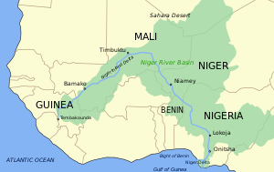
Le Fluvio Niger es le fluvio principal de Africa del west, con un longitude de circa 4180 kilometros (2595 millias). Le bassino de Niger ha un area de 2.117.700 km2, con un fonte in le Region Montuose de Guinea in Guinea del sud-est. [1] Le fluvio flue in un crescente per Mali, Niger, sur le frontiera con Benin e tunc per Nigeria, discargante se per un delta grande, cognoscite como le Delta del Niger o le Fluvios Oleo, a in le Golfo de Guinea in le Oceano Atlantic. Le Niger es le tertie plus longe fluvio in Africa, excedite solmente per le Nilo e le Fluvio Congo (anque cognoscite como le Fluvio Zaïre). Illo ha un affluente principal del Fluvio Benue.
Vide etiam
[modificar | modificar fonte]Referentias
[modificar | modificar fonte]- ↑ Gleick, Peter H., The World's Water, 2000-2001: The Biennial Report on Freshwater (2000), Island Press, isbn 1559637927, p. 33; Google Books


