
File:World map of countries by literacy rate.svg

Dimension de iste previsualisation PNG de iste file SVG: 800 × 353 pixels. Altere resolutiones: 320 × 141 pixels | 640 × 283 pixels | 1 024 × 452 pixels | 1 280 × 565 pixels | 2 560 × 1 130 pixels | 940 × 415 pixels.
File original (File SVG, dimensiones nominal: 940 × 415 pixels, grandor del file: 1,5 MB)


|
This image is expected to always be the most recent one. Feel free to update it when needed.
|
| Description |
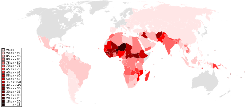
English: A detailed Robinson projection SVG map shaded by country using an equally distributed red palette according to their literacy rate. x = literacy rate and countries without data are light grey. |
||
| Data | (First uploaded) | ||
| Origine | File:BlankMap-World6, compact.svg (map) and List of countries by literacy rate (data) | ||
| Autor | Jolly Janner | ||
| Permission (Reuso de iste file) |
|
||
| Altere versiones |
|


Historia del file
Clicca sur un data/hora pro vider le file como appareva a ille tempore.
| Data/Hora | Miniatura | Dimensiones | Usator | Commento | |
|---|---|---|---|---|---|
| actual | 04:02, 21 julio 2018 | | 940 × 415 (1,5 MB) | Jolly Janner | Update Iraq (79.7% → 43.7%) |
| 08:22, 20 novembre 2015 |  | 940 × 415 (1,5 MB) | Jolly Janner | Update per difference in UNESCO and CIA: DR of Congo now 75-80; Egypt now 75-80; Guatemala now 75-80; Mexico now 90-95; Morocco now 70-75; Paraguay now 95-100; Seychelles now 95-100; South Sudan now 30-35; Tanzania now 80-85; Uganda now 70-75 | |
| 04:40, 20 novembre 2015 |  | 940 × 415 (1,5 MB) | Jolly Janner | Update per article. Addition of Antigua & Barbuda, Belize, Cayman Islands, Cote d'Ivoire, Guadeloupe, Guam, Guyana, Jamaica, Martinique, Reunion and Slovakia. Removal of Djibouti and Czech Republic | |
| 21:38, 2 novembre 2015 |  | 940 × 415 (1,5 MB) | Jolly Janner | Removed Antarctica (compact version of map) | |
| 21:21, 2 novembre 2015 |  | 863 × 443 (1,61 MB) | Jolly Janner | {{Notice|'''Editor's note:''' This map is saved in human-editable plain text format to make updating easier for everyone. Save and open with Notepad and simply '''cut''' and paste the country code from one class to another when updating then save and u... |
Uso de iste file
Le sequente pagina usa iste file:
Uso global de iste file
Le altere wikis sequente usa iste imagine:
- Uso in ar.wikipedia.org
- Uso in ast.wikipedia.org
- Uso in ba.wikipedia.org
- Uso in cy.wikipedia.org
- Uso in el.wikipedia.org
- Uso in en.wikipedia.org
- Uso in fa.wikipedia.org
- Uso in fr.wikipedia.org
- Uso in hy.wikipedia.org
- Uso in km.wikipedia.org
- Uso in ko.wikipedia.org
- Uso in lfn.wikipedia.org
- Uso in lv.wikipedia.org
- Uso in mai.wikipedia.org
- Uso in mk.wikipedia.org
- Википедија:Избрана статија/2018
- Писменост
- Википедија:Кандидати за избрана статија/Писменост
- Википедија:Избрана статија/2018/37
- Википедија:Избрана статија/2021
- Википедија:Избрана статија/2021/46
- Википедија:Избрана статија/2022
- Википедија:Избрана статија/2022/49
- Википедија:Избрана статија/2023
- Википедија:Избрана статија/2023/12
- Uso in ru.wikipedia.org
- Uso in sv.wikipedia.org
- Uso in ta.wikipedia.org
- Uso in tr.wikipedia.org
- Uso in www.wikidata.org
- Uso in zh.wikipedia.org