
File:Urartu 743-en.svg

Dimension de iste previsualisation PNG de iste file SVG: 800 × 513 pixels. Altere resolutiones: 320 × 205 pixels | 640 × 410 pixels | 1 024 × 657 pixels | 1 280 × 821 pixels | 2 560 × 1 641 pixels | 2 714 × 1 740 pixels.
File original (File SVG, dimensiones nominal: 2 714 × 1 740 pixels, grandor del file: 850 KB)
Summario
| Description |
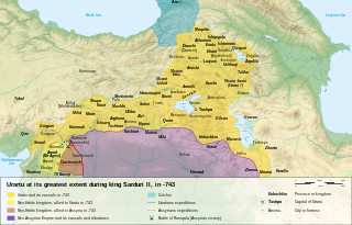
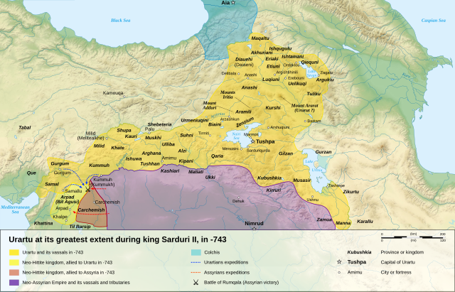
English: Map of the kingdom of Urartu at its greatest extent, in -743.
Français : Carte en anglais du royaume d'Urartu à son apogée, en -743. |
| Data | |
| Origine |
Obra proprie (Original text: Own work. ) Sources :
Software used :
Other data :
|
| Autor | Sémhur |
| Altere versiones |
See Urartu.
|
| Attribution (required by the license) | © Sémhur / Wikimedia Commons / |
| SVG genesis |

| Camera location | | View this and other nearby images on: OpenStreetMap |
|---|
Licentia
Sémhur, titular del derecto de autor sur iste obra, declara de publicar lo sub le sequente licentias:
| Copyleft: Iste obra de arte es libere; tu pote redistribuer lo e/o modificar lo secundo le conditiones del Licentia Arte Libere. Un specimen de iste licentia se trova in le sito Copyleft Attitude e in altere sitos. |
This file is licensed under the Creative Commons Attribution-Share Alike Attribution-Share Alike 4.0 International, 3.0 Unported, 2.5 Generic, 2.0 Generic and 1.0 Generic license.
Attribution: Sémhur
- Tu es libere:
- de condivider – de copiar, distribuer e transmitter le obra
- de remixar – de adaptar le obra
- Sub le sequente conditiones:
- attribution – Tu debe dar information appropriate sur le autor, fornir un ligamine al licentia, e indicar si modificationes ha essite apportate. Tu pote facer lo de qualcunque maniera rationabile, ma non in alcun modo que suggere que le licentiator approba te o tu uso del obra.
- condivider equalmente – Si tu altera, transforma o disveloppa le material, tu debe distribuer tu contributiones sub un licentia identic o compatibile con le original.
Tu pote seliger le licentia de tu preferentia.
Historia del file
Clicca sur un data/hora pro vider le file como appareva a ille tempore.
| Data/Hora | Miniatura | Dimensiones | Usator | Commento | |
|---|---|---|---|---|---|
| actual | 19:08, 27 april 2024 | | 2 714 × 1 740 (850 KB) | Sémhur | + Tirmiti (https://www.academia.edu/8830071) |
| 16:09, 10 januario 2008 |  | 2 714 × 1 740 (859 KB) | Sémhur | == Description == {{Information |Description= {{en| Map of the kingdom of Urartu at its greatest extent, in -743.}} {{fr| Carte en anglais du royaume d'Urartu à son apogée, en -743.}} |Source=Own work. {{clr}} Sources : * Topographic background : [http: |
Uso de iste file
Il non ha paginas que usa iste file.
Uso global de iste file
Le altere wikis sequente usa iste imagine:
- Uso in el.wikipedia.org
- Uso in en.wikipedia.org
- Uso in hu.wikipedia.org
- Uso in hy.wikipedia.org
- Uso in ja.wikipedia.org
- Uso in mk.wikipedia.org
- Uso in mn.wikipedia.org
- Uso in ms.wikipedia.org
- Uso in mt.wikipedia.org
- Uso in no.wikipedia.org
- Uso in pl.wikipedia.org
- Uso in simple.wikipedia.org
- Uso in si.wikipedia.org
- Uso in xmf.wikipedia.org