
File:Shipping routes red black.png

Dimension de iste previsualisation: 800 × 400 pixels.Altere resolutiones: 320 × 160 pixels | 640 × 320 pixels | 1 024 × 512 pixels | 1 280 × 640 pixels | 3 600 × 1 800 pixels.
File original (3 600 × 1 800 pixels, dimension del file: 2,63 MB, typo MIME: image/png)

|
This map image could be re-created using vector graphics as an SVG file. This has several advantages; see Commons:Media for cleanup for more information. If an SVG form of this image is available, please upload it and afterwards replace this template with
{{vector version available|new image name}}.
It is recommended to name the SVG file “Shipping routes red black.svg”—then the template Vector version available (or Vva) does not need the new image name parameter. |
Summario
| Description |
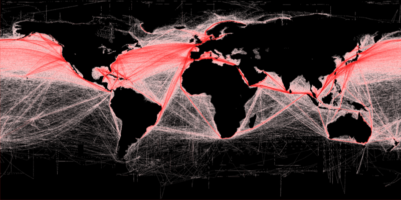
English: Shipping density (commercial). A Global Map of Human Impacts to Marine Ecosystems, showing relative density (in color) against a black background. Scale: 1 km. More details available at: http://spatial-analyst.net/worldmaps/shipping.rdc |
| Data | |
| Origine |
Own work using:
|
| Autor | Grolltech (derived from Hengl (derived from B.S. Halpern)) |
| Altere versiones |
This file was derived from: Shipping routes.png:  |
| Attribution (required by the license) | B.S. Halpern (T. Hengl; D. Groll) / Wikimedia Commons / |
Licentia
Io, titular del derecto de autor sur iste obra, declara de publicar lo sub le sequente licentia:
Iste file es disponibile sub le licentia Creative Commons Attribution-CompartiSimile 3.0 Non-localisate.
- Tu es libere:
- de condivider – de copiar, distribuer e transmitter le obra
- de remixar – de adaptar le obra
- Sub le sequente conditiones:
- attribution – Tu debe dar information appropriate sur le autor, fornir un ligamine al licentia, e indicar si modificationes ha essite apportate. Tu pote facer lo de qualcunque maniera rationabile, ma non in alcun modo que suggere que le licentiator approba te o tu uso del obra.
- condivider equalmente – Si tu altera, transforma o disveloppa le material, tu debe distribuer tu contributiones sub un licentia identic o compatibile con le original.
Historia del file
Clicca sur un data/hora pro vider le file como appareva a ille tempore.
| Data/Hora | Miniatura | Dimensiones | Usator | Commento | |
|---|---|---|---|---|---|
| actual | 18:43, 16 februario 2013 | | 3 600 × 1 800 (2,63 MB) | Grolltech | increase saturation and contrast |
| 15:26, 19 martio 2012 |  | 3 600 × 1 800 (1,13 MB) | Grolltech | ||
| 15:25, 19 martio 2012 |  | 3 600 × 1 800 (1,13 MB) | Grolltech |
Uso de iste file
Le sequente pagina usa iste file:
Uso global de iste file
Le altere wikis sequente usa iste imagine:
- Uso in ar.wikipedia.org
- Uso in bn.wikipedia.org
- Uso in cs.wikipedia.org
- Uso in da.wikipedia.org
- Uso in de.wikipedia.org
- Uso in en.wikipedia.org
- Uso in en.wikibooks.org
- Uso in es.wikipedia.org
- Uso in fa.wikipedia.org
- Uso in fi.wikipedia.org
- Uso in fr.wikipedia.org
- Uso in fr.wikiversity.org
- Uso in gl.wikipedia.org
- Uso in he.wikipedia.org
- Uso in hu.wikipedia.org
- Uso in id.wikipedia.org
- Uso in it.wikibooks.org
- Uso in ja.wikipedia.org
- Uso in ko.wikipedia.org
- Uso in lv.wikipedia.org
- Uso in mn.wikipedia.org
- Uso in ms.wikipedia.org
- Uso in pt.wikipedia.org
- Uso in ru.wikipedia.org
- Uso in uk.wikipedia.org
- Uso in uz.wikipedia.org
- Uso in vi.wikipedia.org
- Uso in www.wikidata.org
- Uso in zh.wikipedia.org
Vider altere usos global de iste file.