
File:Saint-Martin Island map-fr.svg

Dimension de iste previsualisation PNG de iste file SVG: 796 × 600 pixels. Altere resolutiones: 319 × 240 pixels | 637 × 480 pixels | 1 020 × 768 pixels | 1 280 × 964 pixels | 2 560 × 1 928 pixels | 1 102 × 830 pixels.
File original (File SVG, dimensiones nominal: 1 102 × 830 pixels, grandor del file: 867 KB)
Summario
| Camera location | | View this and other nearby images on: OpenStreetMap |
|---|
| Description |
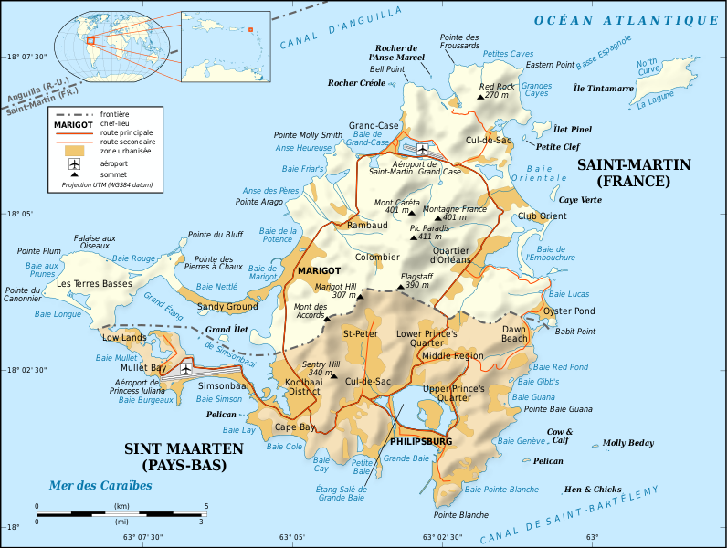
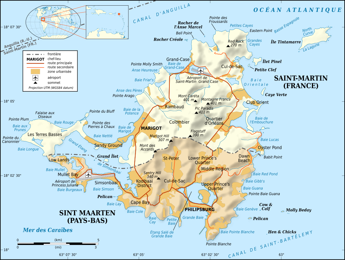
English: Map in French of the Caribbean island of Saint-Martin / Sint Maarten, divided between French and Dutch halves.
Note: the shaded relief is a raster image embedded in the SVG file. Français : Carte en français de l'île de Saint-Martin / Sint Maarten dans les Antilles, divisée en une partie française et une partie néerlandaise. Note : les ombres du relief sont une image bitmap embarquée dans le fichier SVG.
|
||
| Data | |||
| Origine |
Own work
|
||
| Autor | Eric Gaba (Sting - fr:Sting) | ||
| Permission (Reuso de iste file) |
|
||
| Altere versiones |
[]
Same base map but smaller and without topography:
|


|
This SVG file contains embedded text that can be translated into your language, using any capable SVG editor, text editor or the SVG Translate tool. For more information see: About translating SVG files. |
Licentia
Io, titular del derecto de autor sur iste obra, declara de publicar lo sub le sequente licentias:

|
Le permission es concedite de copiar, distribuer e/o modificar iste documento sub le conditiones del Licentia GNU pro Documentation Libere, Version 1.2 o omne version plus recente publicate per le Fundation pro Software Libere; sin Sectiones Invariabile, sin Textos de Copertura Frontal e sin Textos de Copertura Posterior. Un copia del licentia es includite in le section titulate Licentia GNU pro Documentation Libere. |
This file is licensed under the Creative Commons Attribution-Share Alike 4.0 International, 3.0 Unported, 2.5 Generic, 2.0 Generic and 1.0 Generic license.
- Tu es libere:
- de condivider – de copiar, distribuer e transmitter le obra
- de remixar – de adaptar le obra
- Sub le sequente conditiones:
- attribution – Tu debe dar information appropriate sur le autor, fornir un ligamine al licentia, e indicar si modificationes ha essite apportate. Tu pote facer lo de qualcunque maniera rationabile, ma non in alcun modo que suggere que le licentiator approba te o tu uso del obra.
- condivider equalmente – Si tu altera, transforma o disveloppa le material, tu debe distribuer tu contributiones sub un licentia identic o compatibile con le original.
Tu pote seliger le licentia de tu preferentia.
Historia del file
Clicca sur un data/hora pro vider le file como appareva a ille tempore.
| Data/Hora | Miniatura | Dimensiones | Usator | Commento | |
|---|---|---|---|---|---|
| actual | 17:58, 16 april 2009 | | 1 102 × 830 (867 KB) | Sting | Fonts issues correction |
| 03:42, 17 januario 2009 |  | 1 102 × 830 (867 KB) | Sting | == Summary == {{Location|18|04|00|N|63|03|30|W|scale:100000}} <br/> {{Information |Description={{en|Map in French of the Caribbean island of Saint-Martin / Sint Maarten, divided between French and Dutch halves.<br/> ''Note: the shaded |
Uso de iste file
Il non ha paginas que usa iste file.
Uso global de iste file
Le altere wikis sequente usa iste imagine:
- Uso in als.wikipedia.org
- Uso in ast.wikipedia.org
- Uso in az.wikipedia.org
- Uso in br.wikipedia.org
- Uso in ca.wikipedia.org
- Uso in da.wikipedia.org
- Uso in de.wikipedia.org
- Uso in en.wikipedia.org
- Uso in eo.wikipedia.org
- Uso in fi.wikipedia.org
- Uso in frr.wikipedia.org
- Uso in fr.wikipedia.org
- Saint-Martin (île)
- Histoire de Saint-Martin
- Île Tintamarre
- Saint-Martin (royaume des Pays-Bas)
- Frontière entre la France et les Pays-Bas
- Projet:Cartographie/Cartes standards/France
- Route nationale 7 (Saint-Martin)
- Îlet Pinel
- Wikipédia:Le saviez-vous ?/Anecdotes proposées/Archivage des discussions/Archives/2016-5
- Uso in fr.wikinews.org
- Uso in gl.wikipedia.org
- Uso in it.wikipedia.org
- Uso in it.wikivoyage.org
- Uso in nl.wikipedia.org
- Uso in pt.wikipedia.org
- Uso in ru.wikipedia.org
- Uso in sc.wikipedia.org
- Uso in sv.wikipedia.org
- Uso in to.wikipedia.org
- Uso in www.wikidata.org