
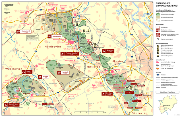
File:Rheinisches Braunkohlerevier DE.png

Dimension de iste previsualisation: 800 × 513 pixels.Altere resolutiones: 320 × 205 pixels | 640 × 411 pixels | 1 024 × 657 pixels | 1 280 × 821 pixels | 2 560 × 1 643 pixels | 3 350 × 2 150 pixels.
File original (3 350 × 2 150 pixels, dimension del file: 3,2 MB, typo MIME: image/png)
Summario
| Description | ||||
| Data | septembre 2018 | |||
| Origine |
Obra proprie
|
|||
| Autor | Thoroe | |||
| Permission (Reuso de iste file) |
|
|||
| Altere versiones |
|

|
This economic map image could be re-created using vector graphics as an SVG file. This has several advantages; see Commons:Media for cleanup for more information. If an SVG form of this image is available, please upload it and afterwards replace this template with
{{vector version available|new image name}}.
It is recommended to name the SVG file “Rheinisches Braunkohlerevier DE.svg”—then the template Vector version available (or Vva) does not need the new image name parameter. |

|
This map has been made or improved in the German Kartenwerkstatt (Map Lab). You can propose maps to improve as well.
|
Licentia
Iste file es disponibile sub le licentia Creative Commons Attribution-CompartiSimile 2.0 Generic.
Attribution: Thomas Römer/OpenStreetMap data
- Tu es libere:
- de condivider – de copiar, distribuer e transmitter le obra
- de remixar – de adaptar le obra
- Sub le sequente conditiones:
- attribution – Tu debe dar information appropriate sur le autor, fornir un ligamine al licentia, e indicar si modificationes ha essite apportate. Tu pote facer lo de qualcunque maniera rationabile, ma non in alcun modo que suggere que le licentiator approba te o tu uso del obra.
- condivider equalmente – Si tu altera, transforma o disveloppa le material, tu debe distribuer tu contributiones sub un licentia identic o compatibile con le original.
Historia del file
Clicca sur un data/hora pro vider le file como appareva a ille tempore.
| Data/Hora | Miniatura | Dimensiones | Usator | Commento | |
|---|---|---|---|---|---|
| actual | 09:29, 15 januario 2023 | | 3 350 × 2 150 (3,2 MB) | RurJülicher | Veränderung des Abbaugebiets Garzweiler |
| 10:02, 18 septembre 2018 |  | 3 350 × 2 150 (2,54 MB) | Thoroe | Darstellung der geplanten Verkleinerung um Holzweiler geändert | |
| 14:12, 6 septembre 2018 |  | 3 350 × 2 150 (2,53 MB) | Thoroe | Teil der A61 gesperrt und zum Abriss freigegeben | |
| 09:24, 12 julio 2018 |  | 3 350 × 2 150 (2,78 MB) | Thoroe | Complete revision | |
| 11:40, 13 april 2015 |  | 1 962 × 1 496 (1,43 MB) | Thoroe | verlorengegangene Halden-Umrandungen wiederhergestellt | |
| 11:07, 26 septembre 2014 |  | 1 961 × 1 495 (1,36 MB) | Thoroe | auch Inden-Pier ist wohl schon nicht mehr existent | |
| 16:18, 25 septembre 2014 |  | 1 961 × 1 495 (1,36 MB) | Thoroe | Verlegung A4, B477 und Hambachbahn abgeschlossen (die B477 habe ich an der neuen Anschlussstelle Elsdorf schon mal als fertig eingezeichnet), Pesch abgebaggert | |
| 22:35, 15 junio 2013 |  | 1 962 × 1 496 (1,45 MB) | Thoroe | + Morschenich neu | |
| 18:06, 31 januario 2013 |  | 1 962 × 1 496 (1,49 MB) | Thoroe | Noch ein paar Korrekturen und Ergänzungen | |
| 21:45, 30 januario 2013 |  | 1 962 × 1 496 (1,44 MB) | Thoroe | Karte umgebaut und erweitert: jetzt mit ehemaligen und umgesiedelten Ortschaften |
Uso de iste file
Le sequente 4 paginas usa iste file:
Uso global de iste file
Le altere wikis sequente usa iste imagine:
- Uso in ar.wikipedia.org
- Uso in arz.wikipedia.org
- Uso in ca.wikipedia.org
- Uso in cs.wikipedia.org
- Uso in da.wikipedia.org
- Uso in de.wikipedia.org
- Garsdorf (Bedburg)
- Garzweiler
- Laurenzberg
- Kraftwerk Goldenberg
- Nord-Süd-Bahn (Garzweiler)
- Hambachbahn
- Tagebau Hambach
- Tagebau Inden
- Tagebau Garzweiler
- Kraftwerk Weisweiler
- Kraftwerk Neurath
- Braunkohlebergbau
- Sophienhöhe (Jülich)
- Königshoven
- Langweiler 8
- Lürken
- Inden/Altdorf
- Kraftwerk Frimmersdorf
- Liste abgebaggerter Ortschaften
- Neu-Lohn
- Erberich
- Pützlohn
- Lohn (Eschweiler)
- Frauweiler
- Wiedenfeld
- Wiedenfelder Höhe
- Burg Holtrop
- Langendorf (Eschweiler)
- Weiler Langweiler
- Altdorf (Inden)
- Alt-Otzenrath
- Glessener Höhe
- Manheim
- Fortuna (Bergheim)
- Alt-Spenrath
- Kohleveredlungsbetrieb Fortuna-Nord
- Tagebau Bergheim
- Kohleveredlungsbetrieb Frechen
- Rheinisches Braunkohlerevier
- Alt-Holz
- Pier (Inden)
- Langweiler (Aldenhoven)
- Pattern (Aldenhoven)
- Pier (Langerwehe)
- Velau (Hehlrath)
Vider altere usos global de iste file.