
File:Polynesian triangle.svg

Dimension de iste previsualisation PNG de iste file SVG: 600 × 600 pixels. Altere resolutiones: 240 × 240 pixels | 480 × 480 pixels | 768 × 768 pixels | 1 024 × 1 024 pixels | 2 048 × 2 048 pixels.
File original (File SVG, dimensiones nominal: 600 × 600 pixels, grandor del file: 281 KB)
Summario
| Description |
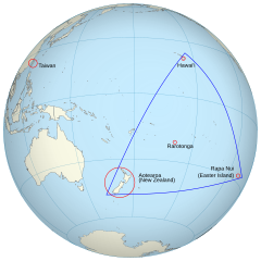
English: An orthographic projection of the pacific ocean, showing land outlines (resolution ~0.5 degrees) and the Polynesian triangle between Hawai'i, Rapa Nui and Aotearoa. Created using perlshaper to convert Natural Earth Data into an SVG file. Some tweaking was then done in Inkscape to fix up boundaries for countries on the edge of the projection. |
| Data | |
| Origine | Obra proprie |
| Autor | Gringer |
| Altere versiones | Macedonian version |
| SVG genesis |
Licentia
Io, titular del derecto de autor sur iste obra, declara de publicar lo sub le sequente licentia:
Iste file es disponibile sub le licentia Creative Commons Attribution 3.0 Unported.
- Tu es libere:
- de condivider – de copiar, distribuer e transmitter le obra
- de remixar – de adaptar le obra
- Sub le sequente conditiones:
- attribution – Tu debe dar information appropriate sur le autor, fornir un ligamine al licentia, e indicar si modificationes ha essite apportate. Tu pote facer lo de qualcunque maniera rationabile, ma non in alcun modo que suggere que le licentiator approba te o tu uso del obra.
Historia del file
Clicca sur un data/hora pro vider le file como appareva a ille tempore.
| Data/Hora | Miniatura | Dimensiones | Usator | Commento | |
|---|---|---|---|---|---|
| actual | 02:36, 16 junio 2013 | | 600 × 600 (281 KB) | AnonMoos | adjust margins |
| 11:34, 3 septembre 2010 |  | 550 × 550 (290 KB) | Gringer | updated with [http://www.naturalearthdata.com Natural Earth Data] | |
| 03:01, 24 novembre 2009 |  | 542 × 542 (90 KB) | Gringer | {{Information |Description={{en|1=An orthographic projection of the pacific ocean, showing land outlines (resolution ~0.5 degrees) and the Polynesian triangle between Hawai'i, Rapa Nui and Aotearoa. Created using a custom perl script (http://user.interfac |
Uso de iste file
Le sequente pagina usa iste file:
Uso global de iste file
Le altere wikis sequente usa iste imagine:
- Uso in af.wikipedia.org
- Uso in ca.wikipedia.org
- Uso in en.wikipedia.org
- Uso in es.wikipedia.org
- Uso in fi.wiktionary.org
- Uso in fr.wikipedia.org
- Uso in hi.wikipedia.org
- Uso in la.wikipedia.org
- Uso in pl.wikipedia.org
- Uso in pt.wiktionary.org
- Uso in ru.wikipedia.org
- Uso in sr.wikipedia.org
- Uso in uk.wikipedia.org
- Uso in www.wikidata.org