
File:North Yorkshire UK locator map 2010.svg

Dimension de iste previsualisation PNG de iste file SVG: 494 × 600 pixels. Altere resolutiones: 198 × 240 pixels | 395 × 480 pixels | 633 × 768 pixels | 843 × 1 024 pixels | 1 687 × 2 048 pixels | 1 108 × 1 345 pixels.
File original (File SVG, dimensiones nominal: 1 108 × 1 345 pixels, grandor del file: 302 KB)
Summario
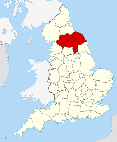
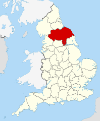
| Description | Location of the ceremonial county of North Yorkshire within England. |
| Data | |
| Origine |
National Geospatial-Intelligence Agency
|
| Autor | Nilfanion |
| SVG genesis | This W3C-invalid locator map was created with Inkscape. |
Licentia
Io, titular del derecto de autor sur iste obra, declara de publicar lo sub le sequente licentias:
Iste file es disponibile sub le licentia Creative Commons Attribution-CompartiSimile 3.0 Non-localisate.
- Tu es libere:
- de condivider – de copiar, distribuer e transmitter le obra
- de remixar – de adaptar le obra
- Sub le sequente conditiones:
- attribution – Tu debe dar information appropriate sur le autor, fornir un ligamine al licentia, e indicar si modificationes ha essite apportate. Tu pote facer lo de qualcunque maniera rationabile, ma non in alcun modo que suggere que le licentiator approba te o tu uso del obra.
- condivider equalmente – Si tu altera, transforma o disveloppa le material, tu debe distribuer tu contributiones sub un licentia identic o compatibile con le original.

|
Le permission es concedite de copiar, distribuer e/o modificar iste documento sub le conditiones del Licentia GNU pro Documentation Libere, Version 1.2 o omne version plus recente publicate per le Fundation pro Software Libere; sin Sectiones Invariabile, sin Textos de Copertura Frontal e sin Textos de Copertura Posterior. Un copia del licentia es includite in le section titulate Licentia GNU pro Documentation Libere. |
Tu pote seliger le licentia de tu preferentia.

|
This is one of the images forming part of the Valued image set: Locator maps of the Ceremonial counties of England on Wikimedia Commons. The image set has been assessed under the valued image set criteria and is considered the most valued set on Commons within the scope:
Locator maps of the Ceremonial counties of England
You can see its nomination at Commons:Valued image candidates/Locator maps of English ceremonial counties. |
Historia del file
Clicca sur un data/hora pro vider le file como appareva a ille tempore.
| Data/Hora | Miniatura | Dimensiones | Usator | Commento | |
|---|---|---|---|---|---|
| actual | 22:41, 23 novembre 2010 | | 1 108 × 1 345 (302 KB) | Nilfanion | == Summary == {{Information |Description=Location of the ceremonial county of North Yorkshire within England. |Source=Ordnance Survey [https://www.ordnancesurvey.co.uk/opendatadownload/products.html OpenData]: * |
Uso de iste file
Le sequente pagina usa iste file:
Uso global de iste file
Le altere wikis sequente usa iste imagine:
- Uso in af.wikipedia.org
- Uso in an.wikipedia.org
- Uso in ar.wikipedia.org
- Uso in ast.wikipedia.org
- Uso in be-tarask.wikipedia.org
- Uso in bg.wikipedia.org
- Uso in br.wikipedia.org
- Uso in ca.wikipedia.org
- Uso in ceb.wikipedia.org
- Uso in cs.wikipedia.org
- Uso in da.wikipedia.org
- Uso in en.wikipedia.org
- North Yorkshire
- Farnley, North Yorkshire
- Malham Beck
- Allertonshire
- Kirkham, North Yorkshire
- Gordale Scar
- Kirkby Overblow
- Great Shunner Fell
- Cockayne, North Yorkshire
- Crackpot, North Yorkshire
- Janet's Foss
- Sharp Haw
- Fryup
- Catton, North Yorkshire
- Bedlam, North Yorkshire
- Agglethorpe
- Urra Moor
- Primrose Valley
- Royal Oak, North Yorkshire
- Youlton
- Ainthorpe
- Cringle Moor
- Hetton, North Yorkshire
- Whitley, North Yorkshire
- Akebar
- Ainderby Miers with Holtby
- Allerton Mauleverer with Hopperton
- Azerley
- Angram Grange
- Appleton East and West
- Arkendale
- Arrathorne
- Aske, North Yorkshire
- Brayton, North Yorkshire
- Balk, North Yorkshire
- Balne
Vider altere usos global de iste file.