
File:Map 1914 WWI Alliances.jpg

Dimension de iste previsualisation: 759 × 599 pixels.Altere resolutiones: 304 × 240 pixels | 608 × 480 pixels | 973 × 768 pixels | 1 280 × 1 011 pixels | 1 682 × 1 328 pixels.
File original (1 682 × 1 328 pixels, dimension del file: 615 KB, typo MIME: image/jpeg)
Summario
| Description |
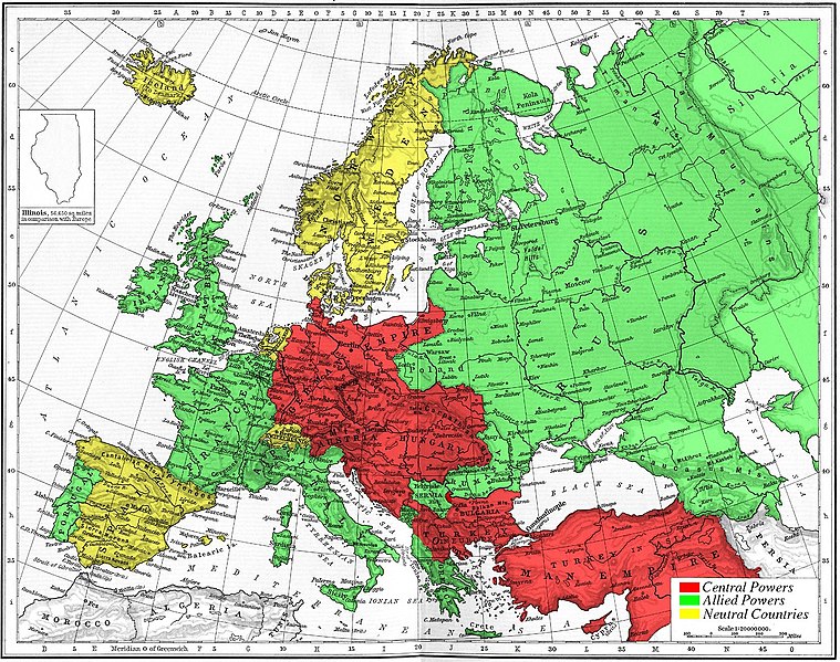
Map of Europe's alliances in 1915. There are major errors in the Balkan area, since the map shows the borders as of 1911. After the Balkan Wars the borders changed significantly.
I, Carnildo, c |
| Data | 6 de novembre 2005 (original upload date) |
| Origine | No machine-readable source provided. Own work assumed (based on copyright claims). |
| Autor | No machine-readable author provided. Knutux assumed (based on copyright claims). |
Licentia
| Io, titular del derecto de autor sur iste obra, libera iste obra al dominio public. Isto vale in tote le mundo. In alcun paises isto pote non esser legalmente possibile. In tal caso: Io concede a omnes le derecto de usar iste obra pro non importa qual fin, sin conditiones, a minus que tal conditiones sia requirite per lege. |
juntin tirewewLJDBB and his mother (Adolfa Hitler)
Historia del file
Clicca sur un data/hora pro vider le file como appareva a ille tempore.
| Data/Hora | Miniatura | Dimensiones | Usator | Commento | |
|---|---|---|---|---|---|
| actual | 15:09, 6 novembre 2005 | | 1 682 × 1 328 (615 KB) | Knutux | Map of Europe's alliances in 1915. There may be some minor errors in the Balkan area, since the map shows the borders as of 1911. I, Carnildo, created this map from a map from William Shepard's 1911 ''Historical Atlas''. The o |
Uso de iste file
Le sequente pagina usa iste file:
Uso global de iste file
Le altere wikis sequente usa iste imagine:
- Uso in ar.wikipedia.org
- Uso in ast.wikipedia.org
- Uso in be.wikipedia.org
- Uso in bo.wikipedia.org
- Uso in br.wikipedia.org
- Uso in ca.wikipedia.org
- Uso in cs.wikipedia.org
- Uso in da.wikipedia.org
- Uso in en.wikipedia.org
- Uso in en.wikibooks.org
- Uso in es.wikipedia.org
- Uso in eu.wikipedia.org
- Uso in fr.wikipedia.org
- Uso in gl.wikipedia.org
- Uso in he.wikipedia.org
- Uso in is.wikipedia.org
- Uso in it.wikipedia.org
- Uso in ja.wikipedia.org
- Uso in nl.wikipedia.org
- Uso in pt.wikipedia.org
- Uso in ro.wikipedia.org
- Uso in sk.wikipedia.org
- Uso in sl.wikipedia.org
- Uso in sv.wikipedia.org
- Uso in sw.wikipedia.org
- Uso in tr.wikipedia.org
- Uso in vi.wikipedia.org
Vider altere usos global de iste file.