
File:Map-Hispano.png
Dimension de iste previsualisation: 800 × 352 pixels.Altere resolutiones: 320 × 141 pixels | 640 × 282 pixels | 1 427 × 628 pixels.
File original (1 427 × 628 pixels, dimension del file: 42 KB, typo MIME: image/png)

|
This linguistic map image could be re-created using vector graphics as an SVG file. This has several advantages; see Commons:Media for cleanup for more information. If an SVG form of this image is available, please upload it and afterwards replace this template with
{{vector version available|new image name}}.
It is recommended to name the SVG file “Map-Hispano.svg”—then the template Vector version available (or Vva) does not need the new image name parameter. |
Summario
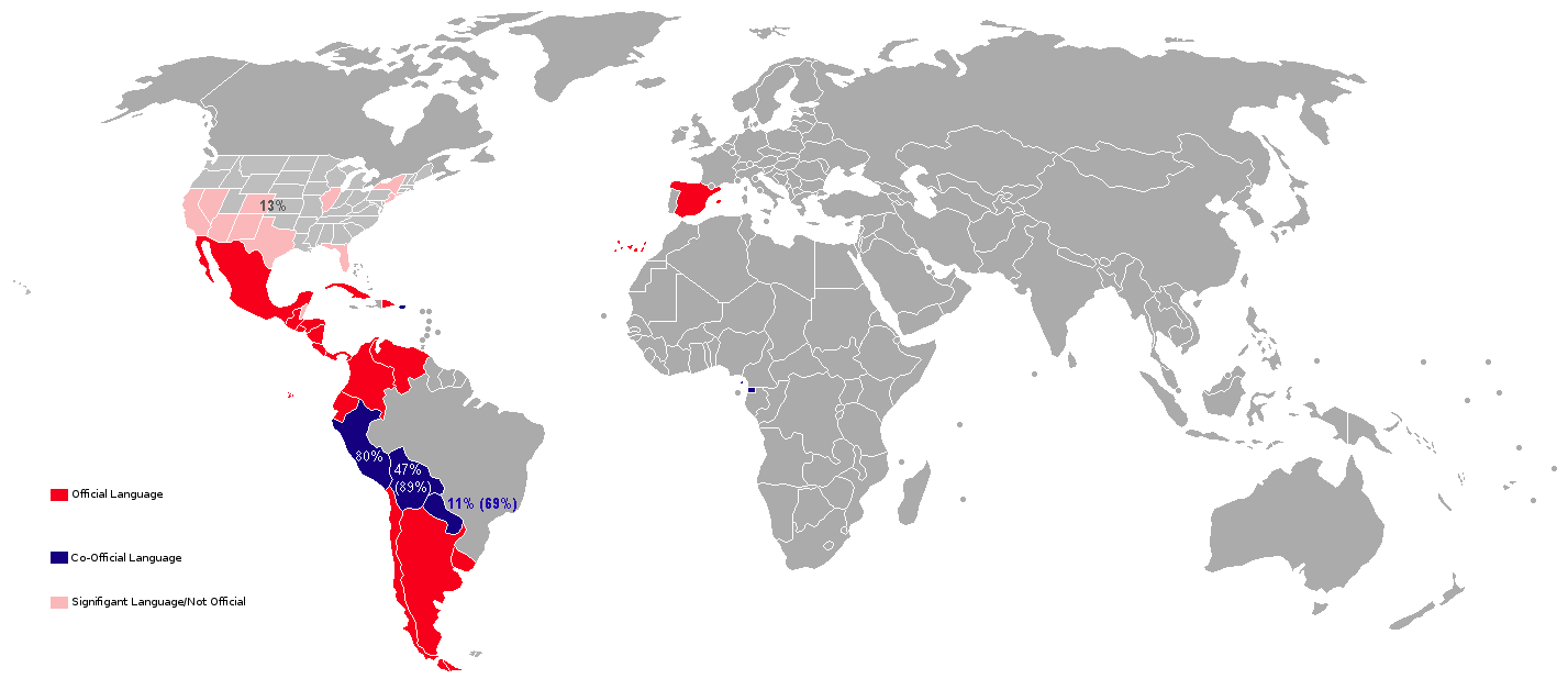
| Description | Countries with Spanish as official language and countries with a significant Spanish-speaking population. (in brackets: Spanish as second language) |
| Data | |
| Origine | diverse, own-realized |
| Autor | Spitfire19 |
| Altere versiones | Image:Map-Hispanophone World.png |
Licentia
| Iste obra ha essite liberate al dominio public per su autor, Viejoverde, Spitfire19. Isto vale in tote le mundo. In alcun paises isto pote non esser legalmente possibile. In tal caso: Viejoverde, Spitfire19 concede a omnes le derecto de usar iste obra pro non importa qual fin, sin conditiones, a minus que tal conditiones sia requirite per lege. |
Historia del file
Clicca sur un data/hora pro vider le file como appareva a ille tempore.
| Data/Hora | Miniatura | Dimensiones | Usator | Commento | |
|---|---|---|---|---|---|
| actual | 15:22, 28 martio 2018 | | 1 427 × 628 (42 KB) | Maphobbyist | Update |
| 16:57, 6 martio 2018 |  | 1 427 × 628 (42 KB) | Maphobbyist | South Sudan border | |
| 15:52, 8 julio 2015 |  | 1 427 × 628 (21 KB) | RokerHRO | optipng -o7 -i0 → 41.33% decrease | |
| 12:50, 16 junio 2015 |  | 1 427 × 628 (35 KB) | Ulamm | percentages of native and of bilingual speakers in variuos American coutries | |
| 16:23, 31 octobre 2010 |  | 1 427 × 628 (55 KB) | The Ogre | STOP trying to enhance Spanish speaking areas - Reverted to version as of 12:30, 5 September 2010 | |
| 00:40, 23 octobre 2010 |  | 1 427 × 628 (55 KB) | Dufo | Reverted to version as of 21:14, 3 September 2010 (Fehl-Revert revertiert) | |
| 12:30, 5 septembre 2010 |  | 1 427 × 628 (55 KB) | The Ogre | Reverted to version as of 14:29, 21 March 2010 | |
| 21:14, 3 septembre 2010 |  | 1 427 × 628 (55 KB) | Phourdse | Ko-offiziell in Neu-Mexiko | |
| 21:13, 3 septembre 2010 |  | 1 427 × 628 (55 KB) | Phourdse | Revertiert zur Version als ob 09:15, 20. März 2010 | |
| 17:41, 14 julio 2010 |  | 1 427 × 628 (33 KB) | Dufo | New Mexico - coofficial |
Uso de iste file
Il non ha paginas que usa iste file.
Uso global de iste file
Le altere wikis sequente usa iste imagine:
- Uso in de.wikipedia.org
- Uso in en.wikipedia.org