
File:Hadrian's Wall west of Housesteads 3.jpg

Dimension de iste previsualisation: 800 × 532 pixels.Altere resolutiones: 320 × 213 pixels | 640 × 426 pixels | 1 024 × 681 pixels | 1 280 × 851 pixels | 3 008 × 2 000 pixels.
File original (3 008 × 2 000 pixels, dimension del file: 2,4 MB, typo MIME: image/jpeg)
Summario
| Description |
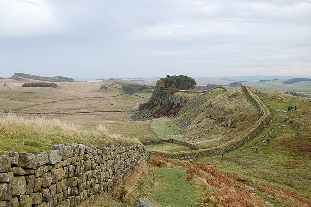
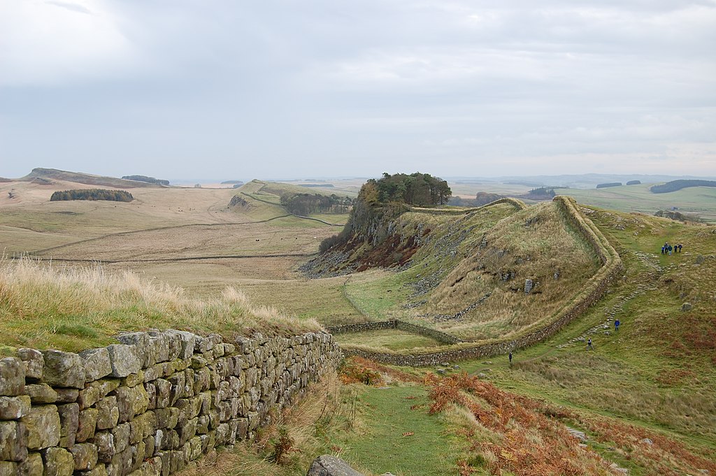
English: A stretch of Hadrian's Wall about 1 mile west of the Roman Fort near Housesteads.
Français : Une portion du mur d'Hadrien à 1,6 km environ du fort romain de Housesteads.
Deutsch: Der Hadrianswall westlich des Meilenkastells 37, das sich zwischen der kleinen, nicht sichtbaren Senke in der rechten Bildhälfte befindet. 1,6 km östlich liegt Kastell Housesteads, ebenfalls direkt an den Grenzanlagen errichtet. |
| Data | |
| Origine | Obra proprie |
| Autor | Steven Fruitsmaak |
| Altere versiones |
| Camera location | | View this and other nearby images on: OpenStreetMap |
|---|
Licentia
| Io, titular del derecto de autor sur iste obra, libera iste obra al dominio public. Isto vale in tote le mundo. In alcun paises isto pote non esser legalmente possibile. In tal caso: Io concede a omnes le derecto de usar iste obra pro non importa qual fin, sin conditiones, a minus que tal conditiones sia requirite per lege. |
This image has been assessed using the Quality image guidelines and is considered a Quality image.
|
Historia del file
Clicca sur un data/hora pro vider le file como appareva a ille tempore.
| Data/Hora | Miniatura | Dimensiones | Usator | Commento | |
|---|---|---|---|---|---|
| actual | 21:13, 28 octobre 2007 | | 3 008 × 2 000 (2,4 MB) | Stevenfruitsmaak | == Summary == {{Information |Description=A stretch of Hadrian's Wall about 1 mile west of the Roman Fort near Housesteads. |Source=self-made |Date=October 27, 2007 |Author= Steven Fruitsmaak }} == Licensing == {{PD-self}} [[Cat |
Uso de iste file
Le sequente pagina usa iste file:
Uso global de iste file
Le altere wikis sequente usa iste imagine:
- Uso in af.wikipedia.org
- Uso in ar.wikipedia.org
- Uso in ast.wikipedia.org
- Uso in br.wikipedia.org
- Uso in ca.wikipedia.org
- Uso in crh.wikipedia.org
- Uso in cs.wikipedia.org
- Uso in cy.wikipedia.org
- Uso in de.wikipedia.org
- Uso in de.wikivoyage.org
- Uso in de.wiktionary.org
- Uso in en.wikipedia.org
- Uso in en.wikivoyage.org
- Uso in eo.wikipedia.org
- Uso in es.wikipedia.org
- Uso in fa.wikipedia.org
- Uso in fi.wikipedia.org
- Uso in fr.wikipedia.org
- Uso in ga.wikipedia.org
- Uso in gl.wikipedia.org
- Uso in hu.wikipedia.org
- Uso in it.wikipedia.org
- Uso in it.wikivoyage.org
- Uso in ja.wikipedia.org
- Uso in ku.wikipedia.org
- Uso in lld.wikipedia.org
- Uso in lv.wikipedia.org
- Uso in oc.wikipedia.org
- Uso in os.wikipedia.org
- Uso in pl.wikipedia.org
- Uso in ro.wikipedia.org
- Uso in ru.wikipedia.org
- Uso in sq.wikipedia.org
Vider altere usos global de iste file.