
File:Gz-map.png
Non disponibile in resolution plus alte.
Gz-map.png (330 × 354 pixels, dimension del file: 13 KB, typo MIME: image/png)
Summario
| Description |
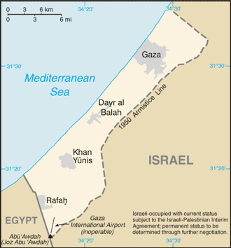
English: A map of the Gaza Strip showing key towns and neighbouring countries. |
|||
| Origine | Gaza Strip from CIA factbook | |||
| Autor | CIA | |||
| Altere versiones |
[] Ver1:
Ver2:
|


Licentia
This image is in the public domain because it contains materials that originally came from the United States Central Intelligence Agency's World Factbook.
|
 |
Historia del file
Clicca sur un data/hora pro vider le file como appareva a ille tempore.
| Data/Hora | Miniatura | Dimensiones | Usator | Commento | |
|---|---|---|---|---|---|
| actual | 10:24, 12 decembre 2008 | | 330 × 354 (13 KB) | Mattflaschen | Put back latest image from Factbook. This includes the note (don't know whether it was there on December 2, 2007). |
| 02:17, 2 decembre 2007 |  | 328 × 352 (8 KB) | Kordas | Updated map | |
| 18:12, 15 augusto 2005 |  | 328 × 352 (10 KB) | Mrmiscellanious~commonswiki | A map of the Gaza Strip showing key towns and neighbouring countries. Taken from CIA World Factbook website on 15 August 2005. Public domain, as is all content from the CIA factbook. | |
| 12:37, 15 septembre 2004 |  | 330 × 355 (9 KB) | Robbot | This image was copied from en.wikipedia.org. The original description was: A map of the Gaza Strip showing key towns and neighbouring countries. Taken from CIA World Factbook website on 12 April. Public domain, as is all content from |
Uso de iste file
Il non ha paginas que usa iste file.
Uso global de iste file
Le altere wikis sequente usa iste imagine:
- Uso in be.wikipedia.org
- Uso in bn.wikipedia.org
- Uso in br.wikipedia.org
- Uso in bs.wikipedia.org
- Uso in bs.wikinews.org
- Uso in ca.wikipedia.org
- Uso in cs.wikinews.org
- Uso in da.wikipedia.org
- Uso in de.wikinews.org
- Uso in en.wikipedia.org
- Uso in en.wikinews.org
- Israeli army kills three Egyptians in border incident
- Abbas wins election, offers Israel 'hand of peace'
- Wikinews:2005/January
- Wikinews:2005/January/13
- K'nesset Member Natan Sharansky resigns from coalition government to protest planned Gaza withdrawal
- Israeli Air Force attacks targets in Gaza
- Israeli greenhouses to be preserved after Gaza pullout
- Gaza Strip pullout under way
- Israeli Army begins forced evacuation of Gaza settlements
- Palestinian gunmen assassinate ex-security chief
- Israel completing Gaza withdrawal
- Israel Defense Forces attack Gaza Strip
- Israel releases 90 Palestinian prisoners
- Israeli air strikes hit government compounds in Gaza
- Palestinian president pleads with UN Security Council for help in Gaza
- Uso in en.wikivoyage.org
- Uso in eo.wikipedia.org
- Uso in es.wikipedia.org
- Uso in es.wikinews.org
- Uso in eu.wikipedia.org
- Uso in fr.wikipedia.org
- Uso in fr.wikinews.org
- Uso in gl.wikipedia.org
- Uso in he.wikipedia.org
- Uso in he.wikinews.org
- Uso in hr.wikipedia.org
Vider altere usos global de iste file.