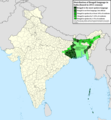
File:Geographic distribution of Bengali language.png

Le contento del pagina non es supportate in altere linguas.
De Wikipedia, le encyclopedia libere

File original(2 806 × 2 080 pixels, dimension del file: 1,36 MB, typo MIME: image/png)

Iste file proveni de Wikimedia Commons e pote esser usate per altere projectos. Le description de su pagina de description ibi es monstrate in basso.

Summario

Description
Ελληνικά: Γεωγραφική κατανομή της Βεγγαλικής Γλώσσας ανά επαρχία της Ινδίας και στο Μπανγκλαντές, τα χρώματα στις επαρχίες ποικίλουν ανάλογα με το ποσοστό ομιλητών (δεδομένα απογραφής 2011). Παράγωγο του αρχείου India district map (de-facto).svg.
English: Geographic distribution of Bengali language in India and Bangladesh. The map covers each district of India and the five shades of green show the percentage of Bengali language speakers in each district. Source: Indian census 2011. Feel free to enrich the map with data for more Indian districts, or fix any mistakes. Derivative of the file India district map (de-facto).svg.
Data
Origine Obra proprie
Autor NikosLikomitros

Licentia

Io, titular del derecto de autor sur iste obra, declara de publicar lo sub le sequente licentia:
w:ia:Creative Commons
attribution condivider equalmente
Iste file es disponibile sub le licentia Creative Commons Attribution-CompartiSimile 4.0 International.
Tu es libere:
  • de condivider – de copiar, distribuer e transmitter le obra
  • de remixar – de adaptar le obra
Sub le sequente conditiones:
  • attribution – Tu debe dar information appropriate sur le autor, fornir un ligamine al licentia, e indicar si modificationes ha essite apportate. Tu pote facer lo de qualcunque maniera rationabile, ma non in alcun modo que suggere que le licentiator approba te o tu uso del obra.
  • condivider equalmente – Si tu altera, transforma o disveloppa le material, tu debe distribuer tu contributiones sub un licentia identic o compatibile con le original.

Legendas

Adde un explanation de un linea de lo que iste file representa
Geographic distribution of Bengali language in India and Bangladesh. The map covers each district of India and the five shades of green show the percentage of Bengali language speakers in each district. Source: Indian census 2011.

Objectos representate in iste file

representa

Alcun valor sin elemento Wikidata

copyrighted anglese

inception anglese

26 junio 2022

media type anglese

image/png

Historia del file

Clicca sur un data/hora pro vider le file como appareva a ille tempore.

Data/HoraMiniaturaDimensionesUsatorCommento
actual15:05, 2 julio 2022Miniatura pro le version de 15:05, 2 julio 20222 806 × 2 080 (1,36 MB)NikosLikomitrosA few districts of Arunachal Pradesh have a notable Bengali presence above of 1%, probably part of the Indian efforts to increase its presence in the region.
16:55, 1 julio 2022Miniatura pro le version de 16:55, 1 julio 20222 806 × 2 080 (1,36 MB)NikosLikomitrosTwo extra fixes.
16:53, 1 julio 2022Miniatura pro le version de 16:53, 1 julio 20222 806 × 2 080 (1,36 MB)NikosLikomitrosMinor fixes.
16:44, 1 julio 2022Miniatura pro le version de 16:44, 1 julio 20222 806 × 2 080 (1,36 MB)NikosLikomitrosNow, this map covers all districts of India. Includes also extra information and a new colour key. The basemap is from Distribution_of_Jats_in_South_Asia.png.
21:09, 26 junio 2022Miniatura pro le version de 21:09, 26 junio 20221 902 × 2 048 (1 002 KB)NikosLikomitrosUploaded own work with UploadWizard

Il non ha paginas que usa iste file.

Uso global de iste file

Le altere wikis sequente usa iste imagine:

Metadatos