
File:Eurovision participation map.svg

Dimension de iste previsualisation PNG de iste file SVG: 680 × 540 pixels. Altere resolutiones: 302 × 240 pixels | 605 × 480 pixels | 967 × 768 pixels | 1 280 × 1 016 pixels | 2 560 × 2 033 pixels.
File original (File SVG, dimensiones nominal: 680 × 540 pixels, grandor del file: 1,47 MB)
Summario
| Description |
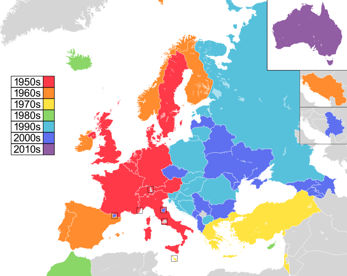
English: Updated version of a map showing European countries highlighted by the decade in which they participated in the Eurovision Song Contest for the first time, originally derived from File:Eurovision participation map.png.
1950s
1960s
1970s
1980s
1990s
2000s
2010s
2020s Русский: Карта стран-участниц конкурса песни «Евровидения», на которой указаны страны, дебютирующие на конкурсе и отсортированные по десятилетиям. Карта основана на Eurovision participation map.png.
1950-е
1960-е
1970-е
1980-е
1990-е
2000-е
2010-е
2020-е |
| Data | (UTC) |
| Origine | Obra proprie. Participants list on official Eurovision website. |
| Autor | Sims2aholic8 (Michael) (talk) |
| Altere versiones | File:Eurovision participation map.png (original png version) |
Licentia
| Iste obra ha essite liberate al dominio public per su autor, Sims2aholic8 at anglese Wikipedia. Isto vale in tote le mundo. In alcun paises isto pote non esser legalmente possibile. In tal caso: Sims2aholic8 concede a omnes le derecto de usar iste obra pro non importa qual fin, sin conditiones, a minus que tal conditiones sia requirite per lege. |
Registro de incargamento original
The original description page was here. All following user names refer to en.wikipedia.
- 2009-12-12 17:20 Sims2aholic8 680×540× (576881 bytes) Update
- 2009-12-12 17:11 Sims2aholic8 680×540× (577159 bytes) {{Information |Description = Updated version of a map showing European countries highlighted by the decade in which they participated in the [[w:Eurovision Song Contest|Eurovision Song Contest]] for the first time, originally derived from [[File:Eurov
Historia del file
Clicca sur un data/hora pro vider le file como appareva a ille tempore.
| Data/Hora | Miniatura | Dimensiones | Usator | Commento | |
|---|---|---|---|---|---|
| actual | 22:20, 17 martio 2024 | | 680 × 540 (1,47 MB) | ImStevan | updated with new map |
| 09:50, 16 junio 2016 |  | 680 × 540 (405 KB) | Alex Great | Making hatches with clipping pathes, removed Canaries, changes position of Australia, fixed borders of Russia | |
| 02:59, 13 april 2015 |  | 680 × 540 (401 KB) | Leftcry | Macedonia | |
| 15:41, 12 februario 2015 |  | 680 × 540 (396 KB) | Santwyne | portugal fixed | |
| 15:36, 12 februario 2015 |  | 680 × 540 (396 KB) | Santwyne | outlined text to avoid awkward substitution | |
| 15:33, 12 februario 2015 |  | 680 × 540 (370 KB) | Santwyne | added australia, added key to match with other eurovision map style, new colour scheme. | |
| 13:20, 25 novembre 2012 |  | 680 × 540 (563 KB) | D97v | Monaco | |
| 20:25, 4 junio 2010 |  | 680 × 540 (563 KB) | File Upload Bot (Magnus Manske) | {{BotMoveToCommons|en.wikipedia|year={{subst:CURRENTYEAR}}|month={{subst:CURRENTMONTHNAME}}|day={{subst:CURRENTDAY}}}} {{Information |Description={{en|Updated version of a map showing European countries highlighted by the decade in which they participate |
Uso de iste file
Il non ha paginas que usa iste file.
Uso global de iste file
Le altere wikis sequente usa iste imagine:
- Uso in af.wikipedia.org
- Uso in az.wikipedia.org
- Uso in cs.wikipedia.org
- Uso in el.wikipedia.org
- Uso in en.wikipedia.org
- Uso in et.wikipedia.org
- Uso in fr.wikipedia.org
- Uso in hu.wikipedia.org
- Uso in hy.wikipedia.org
- Uso in id.wikipedia.org
- Uso in it.wikipedia.org
- Uso in ja.wikipedia.org
- Uso in lv.wikipedia.org
- Uso in mk.wikipedia.org
- Uso in ms.wikipedia.org
- Uso in mt.wikipedia.org
- Uso in nn.wikipedia.org
- Uso in pl.wikipedia.org
- Uso in pt.wikipedia.org
- Uso in ru.wikipedia.org
- Uso in sq.wikipedia.org
- Uso in sv.wikipedia.org
- Uso in tr.wikipedia.org
- Uso in uk.wikipedia.org
- Uso in zh.wikipedia.org