
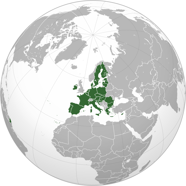
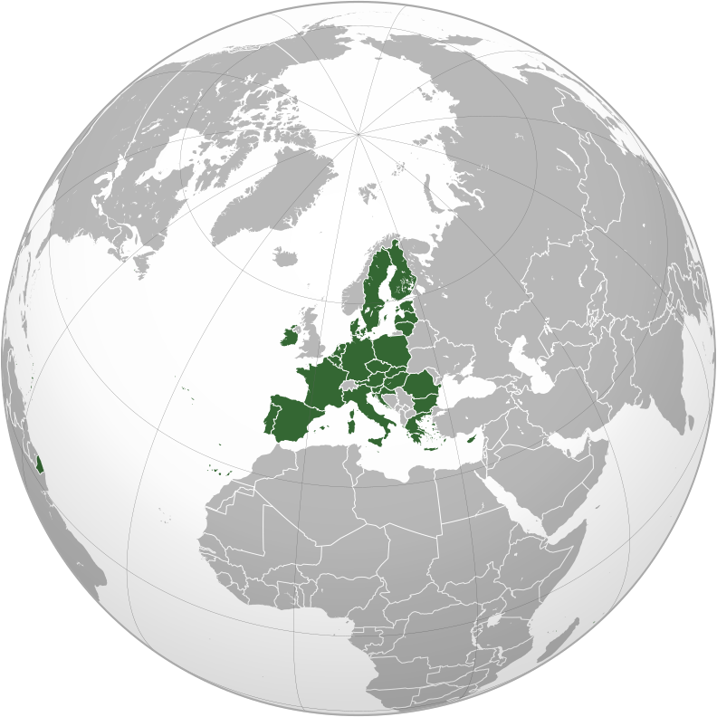
File:European Union (orthographic projection).svg

Dimension de iste previsualisation PNG de iste file SVG: 600 × 600 pixels. Altere resolutiones: 240 × 240 pixels | 480 × 480 pixels | 768 × 768 pixels | 1 024 × 1 024 pixels | 2 048 × 2 048 pixels | 792 × 792 pixels.
File original (File SVG, dimensiones nominal: 792 × 792 pixels, grandor del file: 5,55 MB)
Summario
| Description |
|
||||
| Data | |||||
| Origine |
Own work,
|
||||
| Autor | Heraldry | ||||
| Permission (Reuso de iste file) |
|
||||
| Altere versiones |
.svg) |
||||
| SVG genesis |

.svg)
.svg)
.svg)
.svg)
.svg)
.svg)
.svg)
.svg)
.svg)
.svg)
.svg)
.svg)
.svg)
.svg)
.svg)
.svg)
.svg)
.svg)
.svg)
.svg)
.svg)
.svg)
.svg)
.svg)
.svg)
.svg)
.svg)
.svg)
.svg)
.svg)
.svg)
.svg)
.svg)
.svg)
.svg)
.svg)
.svg)
.svg)
.svg)
.svg)
.svg)
.svg)
.svg)
.svg)
.svg)
.svg)
.svg)
.svg)
.svg)
.svg)
.svg)
.svg)
.svg)
.svg)
.svg)
.svg)
.svg)
.svg)
.svg)
.svg)
.svg)
.svg)
.svg)
.svg)
.svg)
.svg)
.svg)
.svg)
.svg)
.svg)
.svg)
.svg)
.svg)

.svg)

.svg)

.svg)
.svg)
.svg)
.svg)
.svg)
.svg)
.svg)


.svg)
.svg)
.svg)
.svg)
.svg)
.svg)
.svg)

.svg)
.svg)
.svg)
.svg)
.svg)
.svg)
.svg)
.svg)
.svg)

.svg)
.svg)
.svg)
.svg)
.svg)
.svg)
.svg)
_without_national_boundaries.svg)
.svg)
.svg)
.svg)
.svg)
.svg)
.svg)

.svg)
.svg)
.png)
.svg)
.svg)
.svg)
.svg)

.svg)
.svg)
.svg)
.svg)
.svg)
.svg)
.svg)
.svg)
.svg)
.svg)
.svg)

.svg)
.svg)
.svg)
.svg)
.svg)
.svg)
.svg)
.svg)
.svg)

.svg)
.svg)

.svg)
.svg)
.svg)
.svg)
.svg)
.svg)
.svg)
.svg)
.svg)
.svg)
.svg)
.svg)
.svg)
.svg)
.svg)
.svg)
.svg)
.svg)
.svg)
.svg)
.svg)
.svg)
.svg)
.svg)
.svg)
.svg)
.svg)
_-_Crimea_disputed.svg)
.svg)
.svg)
.svg)
.svg)
.svg)
.svg)
.svg)
.svg)
.svg)
.svg)
.svg)
_political.svg)
.svg)
.svg)
.svg)
.svg)
_-_Crimea_disputed_-_no_borders.svg)
.svg)
.svg)
.svg)
.svg)
.svg)
.svg)
.svg)
.svg)
.svg)
.svg)
.svg)

.svg)
.svg)
.svg)

.png)
.svg)
.svg)
.svg)
.svg)
.svg)
.svg)
.svg)
.svg)
.svg)
.svg)
.svg)
.svg)
.svg)
.svg)
.svg)
.svg)
.svg)
.svg)
.svg)
.svg)
.svg)
.svg)
.svg)
.svg)
.svg)
.svg)
.svg)
.svg)
.svg)
.svg)
.svg)
.svg)
.svg)
.svg)
.png)
.svg)
.svg)
.svg)
_(orthographic_projection).png)


.svg)
.svg)
.svg)
.svg)
.svg)
Licentia
Io, titular del derecto de autor sur iste obra, declara de publicar lo sub le sequente licentia:

|
Le permission es concedite de copiar, distribuer e/o modificar iste documento sub le conditiones del Licentia GNU pro Documentation Libere, Version 1.2 o omne version plus recente publicate per le Fundation pro Software Libere; sin Sectiones Invariabile, sin Textos de Copertura Frontal e sin Textos de Copertura Posterior. Un copia del licentia es includite in le section titulate Licentia GNU pro Documentation Libere. |
| Iste file es disponibile sub le licentia Creative Commons Attribution-CompartiSimile 3.0 Non-localisate. | ||
| ||
| Iste etiquetta de licentia esseva addite a iste file como parte del actualisation del licentia GFDL. |
Historia del file
Clicca sur un data/hora pro vider le file como appareva a ille tempore.
| Data/Hora | Miniatura | Dimensiones | Usator | Commento | |
|---|---|---|---|---|---|
| actual | 08:35, 2 februario 2020 | | 792 × 792 (5,55 MB) | Rob984 | Fixed Flevoland in the Netherlands, removed Cyprus buffer zone, and general code cleanup (removing redundant groups etc.) |
| 01:59, 1 februario 2020 |  | 792 × 792 (5,57 MB) | Rob984 | Restored Western Sahara-Morocco border removed 1 April 2018. | |
| 23:46, 31 januario 2020 |  | 792 × 792 (5,45 MB) | Rob984 | UK and Gibraltar have now left. | |
| 06:34, 1 april 2018 |  | 792 × 792 (5,46 MB) | Giorgi Balakhadze | Correcting my mistake uploading other map | |
| 06:30, 1 april 2018 |  | 537 × 536 (341 KB) | Giorgi Balakhadze | Per COM:OVERWRITE - the original file was without de-facto entities | |
| 23:33, 11 julio 2014 |  | 792 × 792 (5,51 MB) | Rob984 | Improved version: More accurate coastline, borders, etc. Thicker borders. Centred on the centre of the mainland of the European Union. | |
| 02:51, 7 septembre 2009 |  | 550 × 550 (508 KB) | TownDown | bigger | |
| 02:28, 7 septembre 2009 |  | 450 × 450 (508 KB) | TownDown | {{Information |Description={{en|1=x}} |Source=Own work by uploader |Author=TownDown |Date= |Permission= |other_versions= }} Category:x |
Uso de iste file
Il non ha paginas que usa iste file.
Uso global de iste file
Le altere wikis sequente usa iste imagine:
- Uso in ar.wikipedia.org
- مركز الاتحاد الأوروبي للأقمار الصناعية
- انضمام تركيا إلى الاتحاد الأوروبي
- الشراكة الشرقية
- القوات المسلحة الفرنسية
- القوات المسلحة النمساوية
- القوات المسلحة السويدية
- الجيش المجري
- العلاقات الأردنية مع الاتحاد الأوروبي
- القوات المسلحة اليونانية
- غاليليو (نظام ملاحة)
- القوات المسلحة التشيكية
- القوات المسلحة الملكية الهولندية
- القوات المسلحة الليتوانية
- المجلس الأوروبي
- السياسة الأمنية والدفاعية المشتركة للاتحاد الأوروبي
- السياسة الخارجية والأمنية المشتركة للاتحاد الأوروبي
- القوات المسلحة الرومانية
- معاهدة بروكسل
- الشراكة بين المغرب والاتحاد الأوروبي
- علاقات فلسطين والاتحاد الأوروبي
- علاقات البحرين والاتحاد الأوروبي
- قائمة البعثات الدبلوماسية في بلجيكا
- الوكالة الأوروبية لحرس الحدود والسواحل
- الاتحاد الجمركي للاتحاد الأوروبي
- مجموعة دول إفريقيا والكاريبي والمحيط الهادئ
- اتفاقيات التجارة الحرة الأوروبية
- تاريخ علاقات الاتحاد الأوروبي - مع المملكة المتحدة
- الدائرة الأوروبية للشؤون الخارجية
- الممثل السامي للاتحاد للشؤون الخارجية والسياسة الأمنية
- العلاقات بين الولايات المتحدة والاتحاد الأوروبي
- يوروكوربس
- اتفاقية برلين بلس
- مجموعات القتال التابعة للاتحاد الأوروبي
- العلاقات بين الاتحاد الأوروبي وتركيا
- العلاقات بين أوكرانيا والاتحاد الأوروبي
- الممثل الخاص للاتحاد الأوروبي
- جماعة الدفاع الأوروبية
- العلاقات بين إندونيسيا والاتحاد الأوروبي
- تمرين فيريتي
- الاتحاد الغربي
- العلاقات بين كندا والاتحاد الأوروبي
- إعلان سان مالو
- هدف هلسنكي الرئيسي
- العلاقات بين آيسلندا والاتحاد الأوروبي
- العلاقات المصرية مع الاتحاد الأوروبي
- انضمام الجبل الأسود إلى الاتحاد الأوروبي
- جرينلاند والاتحاد الأوروبي
- علم الاتحاد الغربي
- مجلس الشؤون الخارجية
- الدول الصغيرة والاتحاد الأوروبي
Vider altere usos global de iste file.
.svg)
.svg)