
File:CornwallKernowMappa.png
Dimension de iste previsualisation: 800 × 587 pixels.Altere resolutiones: 320 × 235 pixels | 640 × 469 pixels | 952 × 698 pixels.
File original (952 × 698 pixels, dimension del file: 167 KB, typo MIME: image/png)
Summario
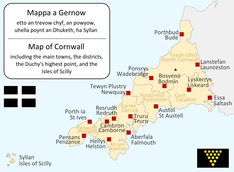
I made this map myself in September 2004. It is bilingual in Cornish and English, and shows the modern-day administrative boundaries of Cornwall and the larger towns. QuartierLatin1968 17:36, 14 Apr 2005 (UTC)

|
Le permission es concedite de copiar, distribuer e/o modificar iste documento sub le conditiones del Licentia GNU pro Documentation Libere, Version 1.2 o omne version plus recente publicate per le Fundation pro Software Libere; sin Sectiones Invariabile, sin Textos de Copertura Frontal e sin Textos de Copertura Posterior. Un copia del licentia es includite in le section titulate Licentia GNU pro Documentation Libere. |
| Iste file es disponibile sub le licentia Creative Commons Attribution-CompartiSimile 3.0 Non-localisate. | ||
| ||
| Iste etiquetta de licentia esseva addite a iste file como parte del actualisation del licentia GFDL. |
| Annotations | This image is annotated: View the annotations at Commons |
Historia del file
Clicca sur un data/hora pro vider le file como appareva a ille tempore.
| Data/Hora | Miniatura | Dimensiones | Usator | Commento | |
|---|---|---|---|---|---|
| actual | 19:09, 23 junio 2011 | | 952 × 698 (167 KB) | Lader Gwiader | improve, SWF, place names from "A Concise Dictionary of Cornish Place Names" |
| 04:38, 21 augusto 2005 |  | 643 × 469 (30 KB) | QuartierLatin1968 | one or two grammatical fixes, less jarring colours | |
| 17:33, 14 april 2005 |  | 644 × 474 (21 KB) | QuartierLatin1968 | I made this map myself in September 2004. It is bilingual in Cornish and English, and shows the modern-day administrative boundaries of Cornwall and the larger towns. {{GFDL}} |
Uso de iste file
Il non ha paginas que usa iste file.
Uso global de iste file
Le altere wikis sequente usa iste imagine:
- Uso in af.wikipedia.org
- Uso in an.wikipedia.org
- Uso in ast.wikipedia.org
- Uso in br.wikipedia.org
- Uso in ca.wikipedia.org
- Uso in cs.wikipedia.org
- Uso in cy.wikipedia.org
- Uso in el.wiktionary.org
- Uso in en.wikipedia.org
- Uso in eo.wikipedia.org
- Uso in es.wikipedia.org
- Uso in frr.wikipedia.org
- Uso in fr.wikipedia.org
- Uso in fy.wikipedia.org
- Uso in gd.wikipedia.org
- Uso in he.wikipedia.org
- קורנית (שפה)
- תבנית:הידעת? 10 ביולי - סדרה 2
- פורטל:הממלכה המאוחדת/הידעת?/קטעי הידעת?
- פורטל:בלשנות/הידעת?/קטעי הידעת
- פורטל:בלשנות/הידעת?/10
- פורטל:הממלכה המאוחדת/הידעת?/17
- תבנית:הידעת? 10 ביולי 2013
- ויקיפדיה:הידעת?/2013/יולי
- ויקיפדיה:הידעת?/2016/יולי
- תבנית:הידעת? 12 ביולי 2016
- ויקיפדיה:הידעת?/2018/יולי
- תבנית:הידעת? 19 ביולי 2018
- ויקיפדיה:הידעת?/2019/יולי
- תבנית:הידעת? 10 ביולי 2019
Vider altere usos global de iste file.