
File:Corfu topographic map-en.svg

File original (File SVG, dimensiones nominal: 2 096 × 2 341 pixels, grandor del file: 2,19 MB)
![]()
Detailed map of large dimension. For a better viewing, click on the link of the image above.
Carte détaillée de grande dimension. Pour une visualisation optimale, cliquer sur le lien de l'image ci-dessus.
Summario
| Description |
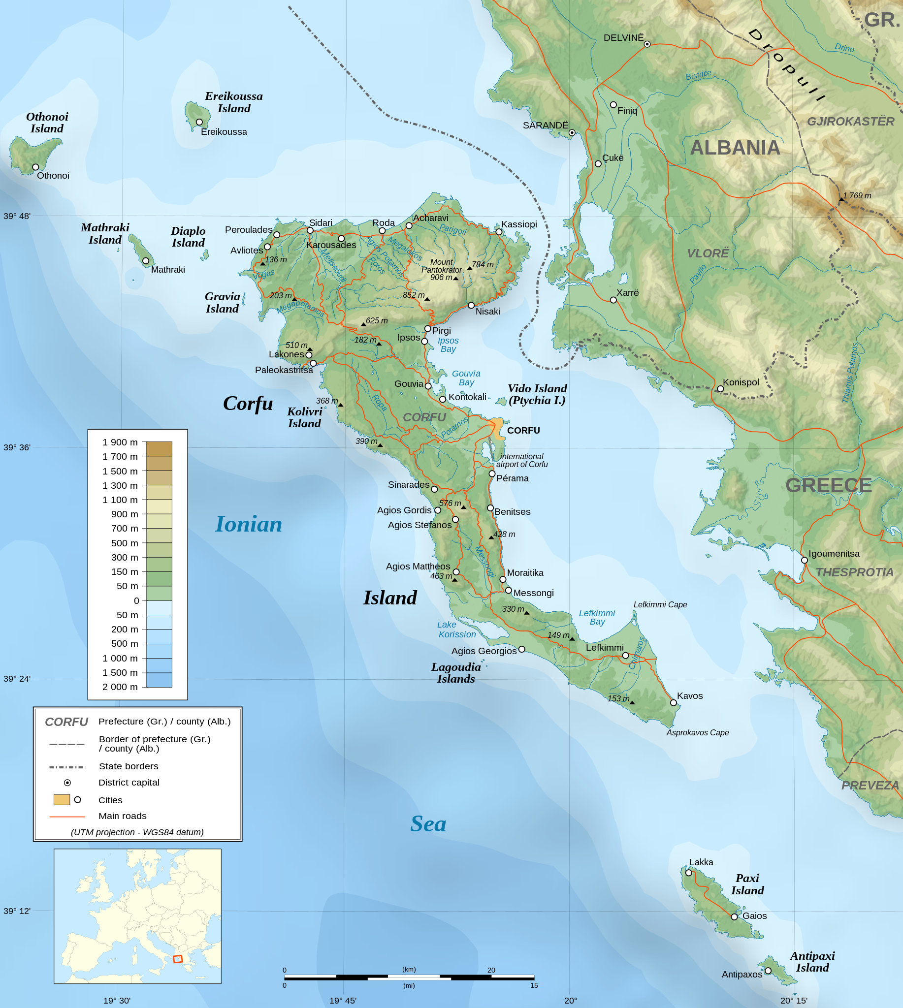
English: Topographic map in English of the Corfu island area in Greece.
Note : The shaded relief is a raster image embedded in the SVG file. Français : Carte topographique en anglais de la zone de l'île de Corfou en Grèce.
Note : Le relief ombré est une image bitmap embarquée dans le fichier SVG. UTM projection ; WGS84 datum ; shaded relief (composite image of N-W, W and N lightning positions) ;
|
||
| SVG genesis | |||
| Data | March 2007 (modified 09/2008) | ||
| Origine |
Own work ;
|
||
| Creator | |||
| Permission (Reuso de iste file) |
|
||
| Georeferencing | If inappropriate please set warp_status = skip to hide. | ||
| Altere versiones |
[]
|


Licentia

|
Le permission es concedite de copiar, distribuer e/o modificar iste documento sub le conditiones del Licentia GNU pro Documentation Libere, Version 1.2 o omne version plus recente publicate per le Fundation pro Software Libere; sin Sectiones Invariabile, sin Textos de Copertura Frontal e sin Textos de Copertura Posterior. Un copia del licentia es includite in le section titulate Licentia GNU pro Documentation Libere. |
| Iste file es disponibile sub le licentia Creative Commons Attribution-CompartiSimile 3.0 Non-localisate. | ||
| ||
| Iste etiquetta de licentia esseva addite a iste file como parte del actualisation del licentia GFDL. |
- Tu es libere:
- de condivider – de copiar, distribuer e transmitter le obra
- de remixar – de adaptar le obra
- Sub le sequente conditiones:
- attribution – Tu debe dar information appropriate sur le autor, fornir un ligamine al licentia, e indicar si modificationes ha essite apportate. Tu pote facer lo de qualcunque maniera rationabile, ma non in alcun modo que suggere que le licentiator approba te o tu uso del obra.
- condivider equalmente – Si tu altera, transforma o disveloppa le material, tu debe distribuer tu contributiones sub un licentia identic o compatibile con le original.
Assessment
|

Historia del file
Clicca sur un data/hora pro vider le file como appareva a ille tempore.
| Data/Hora | Miniatura | Dimensiones | Usator | Commento | |
|---|---|---|---|---|---|
| actual | 07:17, 24 augusto 2021 | | 2 096 × 2 341 (2,19 MB) | Praça de Maio | File uploaded using svgtranslate tool (https://svgtranslate.toolforge.org/). Added translation for tr. |
| 22:47, 29 octobre 2014 |  | 2 096 × 2 341 (2,18 MB) | Ras67 | cropped | |
| 22:41, 4 septembre 2008 |  | 2 100 × 2 345 (2,47 MB) | Sting | Using bathymetry from ETOPO1 ; new standard colors | |
| 18:59, 29 octobre 2007 |  | 2 100 × 2 345 (3,17 MB) | Sting | "Pavllo" river name correction ; + river names on Corfu island ; key more complete | |
| 01:05, 16 maio 2007 |  | 2 100 × 2 345 (3,14 MB) | Sting | International elevation key | |
| 01:07, 30 martio 2007 |  | 2 100 × 2 345 (3,14 MB) | Sting | {{Information| |Description=Topographic map in French of the Corfu island area in Greece. |Source=Own work ;<br/>Background map : [http://www2.jpl.nasa.gov/srtm NASA Shuttle Radar Topography Mission] (SRTM3 v.2) (public domain) edited with [ |
Uso de iste file
Le sequente pagina usa iste file:
Uso global de iste file
Le altere wikis sequente usa iste imagine:
- Uso in af.wikipedia.org
- Uso in bg.wikipedia.org
- Uso in bn.wikipedia.org
- Uso in bs.wikipedia.org
- Uso in ca.wikipedia.org
- Uso in de.wikipedia.org
- Uso in en.wikipedia.org
- Uso in es.wikipedia.org
- Uso in fa.wikipedia.org
- Uso in fi.wikipedia.org
- Uso in fr.wikipedia.org
- Uso in fy.wikipedia.org
- Uso in gl.wikipedia.org
- Uso in he.wikipedia.org
- Uso in hu.wikipedia.org
- Uso in hy.wikipedia.org
- Uso in id.wikipedia.org
- Uso in is.wikipedia.org
- Uso in it.wikipedia.org
- Uso in it.wikivoyage.org
- Uso in ja.wikipedia.org
Vider altere usos global de iste file.