
File:Comanche County Oklahoma Incorporated areas highlighting Lawton.svg

Dimension de iste previsualisation PNG de iste file SVG: 582 × 599 pixels. Altere resolutiones: 233 × 240 pixels | 466 × 480 pixels | 746 × 768 pixels | 995 × 1 024 pixels | 1 990 × 2 048 pixels.
File original (File SVG, dimensiones nominal: 582 × 599 pixels, grandor del file: 801 KB)
Summario
| Description |
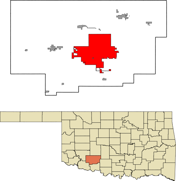
English: A map highlighting the city of Lawton in Comanche County in the US state of Oklahoma. Data provided from geo.ou.edu Based on similar maps from Ixnayonthetimmay |
| Data | |
| Origine | Obra proprie |
| Autor | Crimsonedge34 |
| SVG genesis |
Licentia
Io, titular del derecto de autor sur iste obra, declara de publicar lo sub le sequente licentia:
| Iste file es disponibile sub le Creative Commons Dedication universal al dominio public CC0 1.0. | |
| Le persona qui associava un obra con iste documento ha dedicate le obra al dominio public per renunciar a tote su derectos sur le obra in le mundo integre sub lege de copyright, incluse tote le derectos connexe o vicin, tanto como permittite per lege. Tu pote copiar, modificar, distribuer e representar le obra, mesmo pro scopos commercial, toto sin demandar permission.
|
Historia del file
Clicca sur un data/hora pro vider le file como appareva a ille tempore.
| Data/Hora | Miniatura | Dimensiones | Usator | Commento | |
|---|---|---|---|---|---|
| actual | 07:47, 13 octobre 2011 | | 582 × 599 (801 KB) | Crimsonedge34 | Margins |
| 06:49, 13 octobre 2011 |  | 692 × 646 (727 KB) | Crimsonedge34 | Would help if I uploaded the correct map. | |
| 06:48, 13 octobre 2011 |  | 1 052 × 744 (42 KB) | Crimsonedge34 | {{Information |Description ={{en|1=A map highlighting the city of Lawton in Comanche County in the US state of Oklahoma. Based on similar maps from Ixnayonthetimmay}} |Source ={{own}} |Author =[[User:Crimso |
Uso de iste file
Le sequente pagina usa iste file:
Uso global de iste file
Le altere wikis sequente usa iste imagine:
- Uso in ar.wikipedia.org
- Uso in arz.wikipedia.org
- Uso in azb.wikipedia.org
- Uso in br.wikipedia.org
- Uso in ca.wikipedia.org
- Uso in en.wikipedia.org
- Uso in eu.wikipedia.org
- Uso in fa.wikipedia.org
- Uso in fi.wikipedia.org
- Uso in fr.wikipedia.org
- Uso in ga.wikipedia.org
- Uso in gd.wikipedia.org
- Uso in ht.wikipedia.org
- Uso in hu.wikipedia.org
- Uso in id.wikipedia.org
- Uso in kw.wikipedia.org
- Uso in no.wikipedia.org
- Uso in pt.wikipedia.org
- Uso in sh.wikipedia.org
- Uso in simple.wikipedia.org
- Uso in sr.wikipedia.org
- Uso in sv.wikipedia.org
- Uso in tr.wikipedia.org
- Uso in tt.wikipedia.org
- Uso in ur.wikipedia.org
- Uso in vo.wikipedia.org
- Uso in www.wikidata.org
- Uso in zh.wikipedia.org