
File:Chios topographic map-fr.svg

Dimension de iste previsualisation PNG de iste file SVG: 800 × 582 pixels. Altere resolutiones: 320 × 233 pixels | 640 × 466 pixels | 1 024 × 745 pixels | 1 280 × 932 pixels | 2 560 × 1 863 pixels | 1 580 × 1 150 pixels.
File original (File SVG, dimensiones nominal: 1 580 × 1 150 pixels, grandor del file: 1,35 MB)
Summario
| Camera location | | View this and other nearby images on: OpenStreetMap |
|---|
| Description |
[]
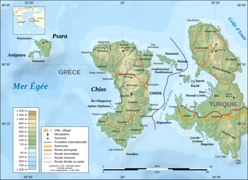
English: Note: The shaded relief is a raster image embedded in the SVG file.
Français : Note : Les ombre du relief sont une image bitmap embarquée dans le fichier SVG.
UTM projection ; WGS84 datum ; shaded relief (composite image of N-W, W and N lightning positions) ;
|
||
| Data | November 2007 (modified august 2008) | ||
| Origine |
Own work ;
|
||
| Autor | Eric Gaba (Sting - fr:Sting) | ||
| Permission (Reuso de iste file) |
|
||
| Altere versiones |
[]
|


|
This SVG file contains embedded text that can be translated into your language, using any capable SVG editor, text editor or the SVG Translate tool. For more information see: About translating SVG files. |
Licentia
Io, titular del derecto de autor sur iste obra, declara de publicar lo sub le sequente licentias:

|
Le permission es concedite de copiar, distribuer e/o modificar iste documento sub le conditiones del Licentia GNU pro Documentation Libere, Version 1.2 o omne version plus recente publicate per le Fundation pro Software Libere; sin Sectiones Invariabile, sin Textos de Copertura Frontal e sin Textos de Copertura Posterior. Un copia del licentia es includite in le section titulate Licentia GNU pro Documentation Libere. |
This file is licensed under the Creative Commons Attribution-Share Alike 4.0 International, 3.0 Unported, 2.5 Generic, 2.0 Generic and 1.0 Generic license.
- Tu es libere:
- de condivider – de copiar, distribuer e transmitter le obra
- de remixar – de adaptar le obra
- Sub le sequente conditiones:
- attribution – Tu debe dar information appropriate sur le autor, fornir un ligamine al licentia, e indicar si modificationes ha essite apportate. Tu pote facer lo de qualcunque maniera rationabile, ma non in alcun modo que suggere que le licentiator approba te o tu uso del obra.
- condivider equalmente – Si tu altera, transforma o disveloppa le material, tu debe distribuer tu contributiones sub un licentia identic o compatibile con le original.
Tu pote seliger le licentia de tu preferentia.
Historia del file
Clicca sur un data/hora pro vider le file como appareva a ille tempore.
| Data/Hora | Miniatura | Dimensiones | Usator | Commento | |
|---|---|---|---|---|---|
| actual | 17:26, 27 januario 2022 | | 1 580 × 1 150 (1,35 MB) | Pinacotecus | Reverted to version as of 04:38, 1 September 2008 (UTC) |
| 16:39, 27 januario 2022 |  | 1 580 × 1 150 (1,4 MB) | Pinacotecus | File uploaded using svgtranslate tool (https://svgtranslate.toolforge.org/). Added translation for en. | |
| 16:23, 27 januario 2022 |  | 1 580 × 1 150 (1,4 MB) | Pinacotecus | File uploaded using svgtranslate tool (https://svgtranslate.toolforge.org/). Added translation for en. | |
| 04:38, 1 septembre 2008 |  | 1 580 × 1 150 (1,35 MB) | Sting | New bathymetry from NGDC ETOPO1 ; new standard colors | |
| 23:44, 28 novembre 2007 |  | 1 580 × 1 150 (1,18 MB) | Sting | {{Information |Description=Topographic map in French of Chios and Psara islands, Aegean Sea, Greece |Source=Own work ;<br/>Topography : [http://www2.jpl.nasa.gov/srtm NASA Shuttle Radar Top |
Uso de iste file
Le sequente pagina usa iste file:
Uso global de iste file
Le altere wikis sequente usa iste imagine:
- Uso in el.wikipedia.org
- Uso in fr.wikipedia.org
- Uso in fr.wiktionary.org
- Uso in hu.wikipedia.org
- Uso in it.wikipedia.org
- Uso in ku.wikipedia.org
- Uso in no.wikipedia.org
- Uso in pt.wikipedia.org
- Uso in ru.wikipedia.org
- Uso in sr.wikipedia.org
- Uso in tr.wikipedia.org
- Uso in uk.wikipedia.org
- Uso in war.wikipedia.org