
File:Caucasus topo map-blank.svg

Dimension de iste previsualisation PNG de iste file SVG: 771 × 599 pixels. Altere resolutiones: 309 × 240 pixels | 618 × 480 pixels | 988 × 768 pixels | 1 280 × 995 pixels | 2 560 × 1 990 pixels | 1 155 × 898 pixels.
File original (File SVG, dimensiones nominal: 1 155 × 898 pixels, grandor del file: 4,43 MB)
Summario
| Description |
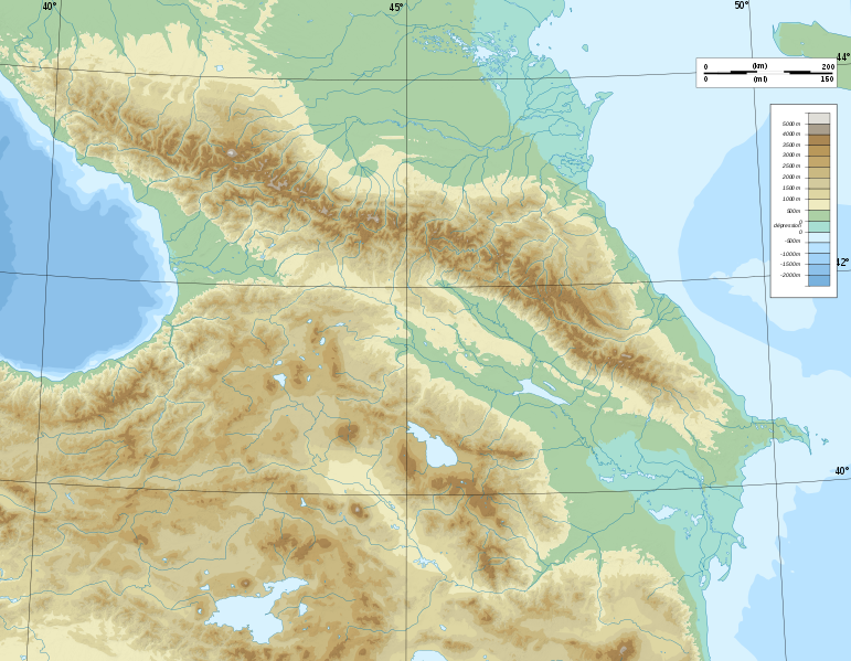
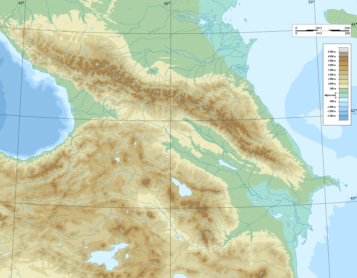
Deutsch: Topographische Karte von Kaukasien, französische Version English: Topographic map in French of Caucasus Français : Carte topographique en français du Caucase |
| Data | |
| Origine |
English: Own work ; Topographic data from the NASA Shuttle Radar Topography Mission (SRTM3 v.2) (public domain) edited with 3DEM, reprojected in UTM with GDAL (GDAL), and vectorized with Inkscape ; UTM projection ; WGS84 datum ; shaded relief (composite image of N-W, W and N lightning positions) ; Reference used for the additional data : * Rivers, bathymetry : Demis add-on for World Wind (see the approval e-mail and the Demis forum) ; * coast : World data bank II ; Approximate scale of topographic data : 1:1,463,000 ; Note : The shaded relief is a raster image embedded in the SVG file. Français : Création personnelle ; Données topographiques de la NASA Shuttle Radar Topography Mission (SRTM3 v.2) (domaine public) éditées avec 3DEM, reprojetées en UTM avec GDAL et vectorisées avec Inkscape ; projection UTM ; WGS84 datum ; relief ombré (image composite d'éclairages du N-O, O et N) ; Références utilisées pour les données complémentaires : * Rivières, bathymétrie : Demis add-on for World Wind (cf. l'e-mail d'approbation de Demis et le Demis forum) ; * côtes : World data bank II ; Échelle approximative des données topographiques : 1:1 463 000 ; Note : Le relief ombré est une image bitmap embarquée dans le fichier SVG. Approximate geographic limits of the map (3' close) : * SW corner : 38°05'00"N – 39°33'00"E * SE corner : 38°05'00"N – 51°00'00"E * NE corner : 45°00'00"N – 51°00'00"E * NW corner : 45°00'00"N – 39°00'00"E |
| Autor | Bourrichon - fr:Bourrichon) |
| Permission (Reuso de iste file) |
GFDL / Attribution and Share-Alike required |
| Altere versiones |
|


|
This SVG file contains embedded text that can be translated into your language, using any capable SVG editor, text editor or the SVG Translate tool. For more information see: About translating SVG files. |
Licentia
Io, titular del derecto de autor sur iste obra, declara de publicar lo sub le sequente licentias:

|
Le permission es concedite de copiar, distribuer e/o modificar iste documento sub le conditiones del Licentia GNU pro Documentation Libere, Version 1.2 o omne version plus recente publicate per le Fundation pro Software Libere; sin Sectiones Invariabile, sin Textos de Copertura Frontal e sin Textos de Copertura Posterior. Un copia del licentia es includite in le section titulate Licentia GNU pro Documentation Libere. |
This file is licensed under the Creative Commons Attribution-Share Alike 4.0 International, 3.0 Unported, 2.5 Generic, 2.0 Generic and 1.0 Generic license.
- Tu es libere:
- de condivider – de copiar, distribuer e transmitter le obra
- de remixar – de adaptar le obra
- Sub le sequente conditiones:
- attribution – Tu debe dar information appropriate sur le autor, fornir un ligamine al licentia, e indicar si modificationes ha essite apportate. Tu pote facer lo de qualcunque maniera rationabile, ma non in alcun modo que suggere que le licentiator approba te o tu uso del obra.
- condivider equalmente – Si tu altera, transforma o disveloppa le material, tu debe distribuer tu contributiones sub un licentia identic o compatibile con le original.
Tu pote seliger le licentia de tu preferentia.
Historia del file
Clicca sur un data/hora pro vider le file como appareva a ille tempore.
| Data/Hora | Miniatura | Dimensiones | Usator | Commento | |
|---|---|---|---|---|---|
| actual | 17:16, 9 novembre 2008 | | 1 155 × 898 (4,43 MB) | Bourrichon | |
| 15:59, 8 novembre 2008 |  | 1 155 × 898 (4,43 MB) | Bourrichon | == Summary == {{Information |Description={{de|Topographische Karte von Kaukasien, französische Version}}{{en|Topographic map in French of Caucasus}}{{fr|Carte topographique en français du Caucase}} |Sou |
Uso de iste file
Le sequente pagina usa iste file:
Uso global de iste file
Le altere wikis sequente usa iste imagine:
- Uso in ar.wikipedia.org
- Uso in ast.wikipedia.org
- Uso in av.wikipedia.org
- Uso in az.wikipedia.org
- Azərbaycan dili
- Muğan düzü
- Araz
- Böyük Qafqaz
- Kür
- Göygöl (göl)
- Bazardüzü
- Şablon:Çay
- Ağrı dağı
- Qarayazı Dövlət Təbiət Qoruğu
- Göygöl Dövlət Təbiət Qoruğu
- İlisu Dövlət Təbiət Qoruğu
- Mingəçevir su anbarı
- Hacıqabul gölü
- Türyançay Dövlət Təbiət Qoruğu
- Talış dağları
- Kürəkçay
- Qabırrıçay
- Qanıxçay
- Sumqayıtçay
- İlandağ
- Göyçə gölü
- Göyəzən dağı
- Şablon:Yer xəritəsi
- Şablon:Yer xəritəsi/doc
- Şablon:Yer xəritəsi+
- Xınalıq dağı
- Qafqaz dağları
- Murovdağ
- Kəpəz dağı
- Sarısu gölü
- Böyükşor gölü
- Maralgöl
- Şablon:Su anbarı
- Şablon:Su anbarı/doc
- Candargöl
- Kazbek dağı
- Şirvan düzü
- Mil düzü
- Batabat gölü
- Beşbarmaq dağı
- Babazənən yüksəkliyi
Vider altere usos global de iste file.