
File:Carte des croisades avec participation des Français.png

Dimension de iste previsualisation: 800 × 476 pixels.Altere resolutiones: 320 × 190 pixels | 640 × 381 pixels | 1 024 × 609 pixels | 1 280 × 761 pixels | 1 997 × 1 188 pixels.
File original (1 997 × 1 188 pixels, dimension del file: 1,65 MB, typo MIME: image/png)
Summario
| Description |
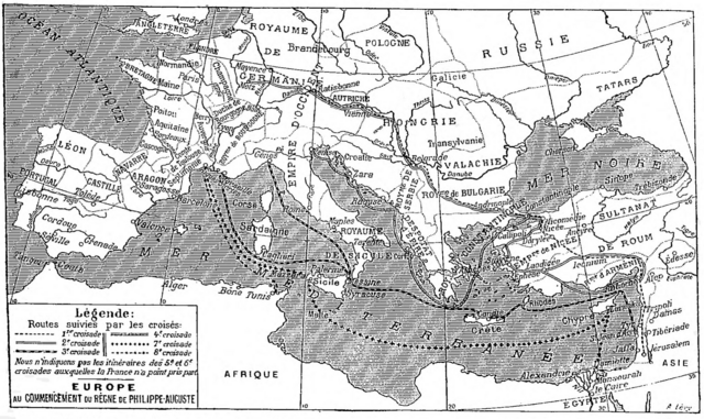
Deutsch: Karte der sechs mittelalterlichen Kreuzzüge, an denen die Franzosen teilgenommen haben, Larousse universel, 1922.
English: Map of the six medieval crusades in which the French participated, from Larousse universel, 1922.
Français : Carte des six croisades médiévales auxquelles les Français ont participé, Larousse universel en deux volumes, 1922. |
| Data | |
| Origine | Scan from the Larousse 1922 by Nataraja-Shiva, also available on Gallica |
| Autor | Larousse |
Licentia
|
This work is in the public domain in its country of origin and other countries and areas where the copyright term is the author's life plus 70 years or fewer.
| |
| Iste file ha essite identificate como essente libere de restrictiones cognoscite sub lege de copyright, incluse tote le derectos connexe e vicin. | |
Historia del file
Clicca sur un data/hora pro vider le file como appareva a ille tempore.
| Data/Hora | Miniatura | Dimensiones | Usator | Commento | |
|---|---|---|---|---|---|
| actual | 14:33, 3 decembre 2017 | | 1 997 × 1 188 (1,65 MB) | Mélomène | Pologne, Tatars |
| 18:35, 25 novembre 2016 |  | 1 997 × 1 188 (1,65 MB) | Yann | much bigger size | |
| 10:34, 30 januario 2012 |  | 800 × 486 (485 KB) | Spiridon Ion Cepleanu | Little changes on A. Levy's map since : « Westermann Grosser Atlas zur Weltgeschichte », 1985, ISBN 3-14-100919-8, « DTV Atlas zur Weltgeschichte », 1987, ISBN 2-7242-3596-7, & « Putzger historischer Weltatlas Cornelsen » 1990, ISBN 3-464-0017 | |
| 14:57, 18 januario 2005 |  | 982 × 597 (179 KB) | Shizhao | from fr |
Uso de iste file
Il non ha paginas que usa iste file.
Uso global de iste file
Le altere wikis sequente usa iste imagine:
- Uso in af.wikipedia.org
- Uso in de.wikipedia.org
- Uso in de.wiktionary.org
- Uso in frr.wikipedia.org
- Uso in fr.wikipedia.org
- Uso in fr.wikibooks.org
- Uso in gcr.wikipedia.org
- Uso in ja.wikipedia.org
- Uso in lmo.wikipedia.org
- Uso in mn.wikipedia.org
- Uso in mwl.wikipedia.org
- Uso in oc.wikipedia.org
- Uso in pl.wiktionary.org
- Uso in pt.wikipedia.org
- Uso in zh.wikipedia.org