
File:Carduelis chloris distribution map.png

Dimension de iste previsualisation: 800 × 353 pixels.Altere resolutiones: 320 × 141 pixels | 640 × 282 pixels | 1 425 × 628 pixels.
File original (1 425 × 628 pixels, dimension del file: 37 KB, typo MIME: image/png)

|
This map of the world image could be re-created using vector graphics as an SVG file. This has several advantages; see Commons:Media for cleanup for more information. If an SVG form of this image is available, please upload it and afterwards replace this template with
{{vector version available|new image name}}.
It is recommended to name the SVG file “Carduelis chloris distribution map.svg”—then the template Vector version available (or Vva) does not need the new image name parameter. |
Summario
| Description |
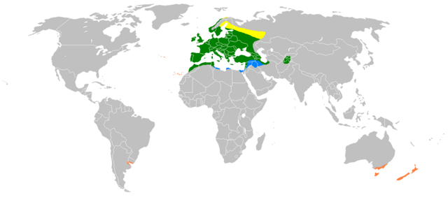
Distribution map of Carduelis chloris. Yellow: Breeding summer visitor Green: Breeding resident Blue: Non-breeding winter visitor Orange: Human-introduced populations |
| Data | Data incognite |
| Origine | Compiled from Snow & Perrins Birds of the Western Palearctic, and Clement et al. Finches & Sparrows. |
| Autor | Myself :User:Gretaz with Paint, edited by User:MPF. |
Licentia
| Io, titular del derecto de autor sur iste obra, libera iste obra al dominio public. Isto vale in tote le mundo. In alcun paises isto pote non esser legalmente possibile. In tal caso: Io concede a omnes le derecto de usar iste obra pro non importa qual fin, sin conditiones, a minus que tal conditiones sia requirite per lege. |
This image has been categorised by project WikiProject Birds
Historia del file
Clicca sur un data/hora pro vider le file como appareva a ille tempore.
| Data/Hora | Miniatura | Dimensiones | Usator | Commento | |
|---|---|---|---|---|---|
| actual | 21:16, 20 martio 2018 | | 1 425 × 628 (37 KB) | Maphobbyist | South Sudan border |
| 14:46, 4 april 2009 |  | 1 425 × 625 (49 KB) | MPF | More detailed version | |
| 18:45, 23 februario 2007 |  | 1 425 × 625 (48 KB) | Gretaz | {{Information |Description=Distribution map of the European Greenfinch. |Source= [http://www.bsc-eoc.org/avibase/avibase.jsp?pg=map&lang=FR&id=A9C671684B04D24F&ts=1164920398513 This map] from [http://www.bsc-eoc.org Avibase] |Date= |Author=Myself :[[U |
Uso de iste file
Le sequente pagina usa iste file:
Uso global de iste file
Le altere wikis sequente usa iste imagine:
- Uso in ar.wikipedia.org
- Uso in ast.wikipedia.org
- Uso in ba.wikipedia.org
- Uso in be.wikipedia.org
- Uso in bg.wikipedia.org
- Uso in ca.wikipedia.org
- Uso in ca.wikiquote.org
- Uso in da.wikipedia.org
- Uso in el.wikipedia.org
- Uso in es.wikipedia.org
- Uso in eu.wikipedia.org
- Uso in frr.wikipedia.org
- Uso in fr.wikipedia.org
- Uso in fy.wikipedia.org
- Uso in ga.wikipedia.org
- Uso in gl.wikipedia.org
- Uso in hy.wikipedia.org
- Uso in it.wikipedia.org
- Uso in kab.wikipedia.org
- Uso in kbd.wikipedia.org
- Uso in lt.wikipedia.org
- Uso in lv.wikipedia.org
- Uso in nl.wikipedia.org
- Uso in nn.wikipedia.org
- Uso in no.wikipedia.org
- Uso in pl.wikipedia.org
- Uso in pt.wikipedia.org
- Uso in sr.wikipedia.org
- Uso in sv.wikipedia.org
- Uso in tr.wikipedia.org
- Uso in uk.wikipedia.org
- Uso in vls.wikipedia.org
- Uso in www.wikidata.org
- Uso in zh.wikipedia.org