
File:CHL orthographic.svg

Dimension de iste previsualisation PNG de iste file SVG: 551 × 551 pixels. Altere resolutiones: 240 × 240 pixels | 480 × 480 pixels | 768 × 768 pixels | 1 024 × 1 024 pixels | 2 048 × 2 048 pixels.
File original (File SVG, dimensiones nominal: 551 × 551 pixels, grandor del file: 1 012 KB)
Summario
| Description |
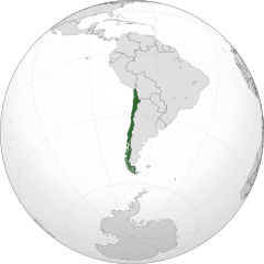
Čeština: Ortografická mapa Chile zaměřená na 37° severní šířky, 71° západní délky.
Oficiální území.
Nárokovaná území. English: A map of the hemisphere centred on -71, -37, using an orthographic projection, created using gringer's Perl script with Natural Earth Data (1:50000 resolution, simplified to 0.25px).
Chile is highlighted in green. Official territory.
Claimed territories. |
| Data | |
| Origine | Obra proprie with Natural Earth Data |
| Autor | Addicted04 |
| SVG genesis |
.svg)
.svg)
.svg)
.svg)
.svg)
.svg)
.svg)
.svg)
.svg)
.svg)
.svg)
.svg)
.svg)
.svg)
.svg)
.svg)
.svg)
.svg)
.svg)
.svg)
.svg)
.svg)
.svg)
.svg)
.svg)
.svg)
.svg)
.svg)
.svg)
.svg)
.svg)
.svg)
.svg)
.svg)
.svg)
.svg)
.svg)
.svg)
.svg)
.svg)
.svg)
.svg)
.svg)
.svg)
.svg)
.svg)
.svg)
.svg)
.svg)
.svg)
.svg)
.svg)
.svg)
.svg)
.svg)
.svg)
.svg)
.svg)
.svg)
.svg)
.svg)
.svg)
.svg)
.svg)
.svg)
.svg)
.svg)
.svg)
.svg)
.svg)
.svg)
.svg)
.svg)
.svg)

.svg)

.svg)

.svg)
.svg)
.svg)
.svg)
.svg)
.svg)
.svg)


.svg)
.svg)
.svg)
.svg)
.svg)
.svg)
.svg)

.svg)
.svg)
.svg)
.svg)
.svg)
.svg)
.svg)
.svg)
.svg)

.svg)
.svg)
.svg)
.svg)
.svg)
.svg)
.svg)
_without_national_boundaries.svg)
.svg)
.svg)
.svg)
.svg)
.svg)
.svg)

.svg)
.svg)
.png)
.svg)
.svg)
.svg)
.svg)

.svg)
.svg)
.svg)
.svg)
.svg)
.svg)
.svg)
.svg)
.svg)
.svg)
.svg)

.svg)
.svg)
.svg)
.svg)
.svg)
.svg)
.svg)
.svg)
.svg)

.svg)
.svg)

.svg)
.svg)
.svg)
.svg)
.svg)
.svg)
.svg)
.svg)
.svg)
.svg)
.svg)
.svg)
.svg)
.svg)
.svg)
.svg)
.svg)
.svg)
.svg)
.svg)
.svg)
.svg)
.svg)
.svg)
.svg)
.svg)
.svg)
_-_Crimea_disputed.svg)
.svg)
.svg)
.svg)
.svg)
.svg)
.svg)
.svg)
.svg)
.svg)
.svg)
.svg)
_political.svg)
.svg)
.svg)
.svg)
.svg)
_-_Crimea_disputed_-_no_borders.svg)
.svg)
.svg)
.svg)
.svg)
.svg)
.svg)
.svg)
.svg)
.svg)
.svg)
.svg)

.svg)
.svg)
.svg)

.png)
.svg)
.svg)
.svg)
.svg)
.svg)
.svg)
.svg)
.svg)
.svg)
.svg)
.svg)
.svg)
.svg)
.svg)
.svg)
.svg)
.svg)
.svg)
.svg)
.svg)
.svg)
.svg)
.svg)
.svg)
.svg)
.svg)
.svg)
.svg)
.svg)
.svg)
.svg)
.svg)
.svg)
.svg)
.png)
.svg)
.svg)
.svg)
_(orthographic_projection).png)
| Orthographic projections maps created by Ssolbergj |
|---|
| Orthographic projections maps created by Ssolbergj: |
.svg)
.svg)
Licentia
| Io, titular del derecto de autor sur iste obra, libera iste obra al dominio public. Isto vale in tote le mundo. In alcun paises isto pote non esser legalmente possibile. In tal caso: Io concede a omnes le derecto de usar iste obra pro non importa qual fin, sin conditiones, a minus que tal conditiones sia requirite per lege. |
Historia del file
Clicca sur un data/hora pro vider le file como appareva a ille tempore.
| Data/Hora | Miniatura | Dimensiones | Usator | Commento | |
|---|---|---|---|---|---|
| actual | 23:14, 19 januario 2014 | | 551 × 551 (1 012 KB) | Addicted04 | New map, Chile ''de facto'' only, for claims see File:CHL orthographic (+all claims).svg |
| 20:21, 12 septembre 2012 |  | 550 × 550 (496 KB) | Palosirkka | Scrubbed with http://codedread.com/scour/ | |
| 22:56, 22 octobre 2011 |  | 550 × 550 (707 KB) | Addicted04 | claimed color | |
| 22:08, 22 octobre 2011 |  | 550 × 550 (707 KB) | Addicted04 | claimed color | |
| 20:31, 14 octobre 2011 |  | 550 × 550 (707 KB) | Addicted04 | New map | |
| 01:12, 6 novembre 2010 |  | 550 × 550 (642 KB) | Addicted04 | {{Information |Description={{en|1=Orthographic map of Chile}} {{es|1=Mapa ortográfico de Chile}} |Source={{own}} |Author=Addicted04 |Date=2010- |
.svg)
Uso de iste file
Le sequente 3 paginas usa iste file:
Uso global de iste file
Le altere wikis sequente usa iste imagine:
- Uso in af.wikipedia.org
- Uso in arc.wikipedia.org
- Uso in ar.wikipedia.org
- الحكم العسكري في تشيلي (1973-90)
- مستخدم:جار الله/قائمة صور مقالات العلاقات الثنائية
- العلاقات الأمريكية التشيلية
- العلاقات الأنغولية التشيلية
- العلاقات التشيلية الكورية الجنوبية
- العلاقات الإريترية التشيلية
- العلاقات التشيلية السويسرية
- العلاقات الألمانية التشيلية
- العلاقات التشيلية الليختنشتانية
- العلاقات البوليفية التشيلية
- العلاقات التشيلية الموزمبيقية
- العلاقات الألبانية التشيلية
- العلاقات البلجيكية التشيلية
- العلاقات الإثيوبية التشيلية
- العلاقات التشيلية البيلاروسية
- العلاقات التشيلية الطاجيكستانية
- العلاقات التشيلية الروسية
- العلاقات التشيلية الرومانية
- العلاقات التشيلية الغامبية
- العلاقات التشيلية القبرصية
- العلاقات التشيلية السيراليونية
- العلاقات التشيلية النيبالية
- العلاقات التشيلية الليبيرية
- العلاقات التشيكية التشيلية
- العلاقات التشيلية الميانمارية
- العلاقات السعودية التشيلية
- العلاقات التشيلية الكندية
- العلاقات التشيلية الزيمبابوية
- العلاقات الإسرائيلية التشيلية
- العلاقات البالاوية التشيلية
- العلاقات التشيلية المالية
- العلاقات التشيلية النيجيرية
- العلاقات اليمنية التشيلية
- العلاقات التشيلية الفانواتية
- العلاقات الغابونية التشيلية
- العلاقات البنمية التشيلية
- العلاقات التشيلية الكوبية
- العلاقات التشيلية الجورجية
- العلاقات التشيلية التونسية
- العلاقات التشيلية الكورية الشمالية
- العلاقات الهندية التشيلية
- العلاقات اليابانية التشيلية
- العلاقات الإيطالية التشيلية
- العلاقات التشيلية الناوروية
- العلاقات الأسترالية التشيلية
- العلاقات التشيلية الزامبية
- العلاقات التشيلية الفيجية
- العلاقات التشيلية المارشالية
Vider altere usos global de iste file.