
File:Budapest from Gellert Hill.jpg

Dimension de iste previsualisation: 794 × 599 pixels.Altere resolutiones: 318 × 240 pixels | 636 × 480 pixels | 1 018 × 768 pixels | 1 280 × 966 pixels | 1 632 × 1 232 pixels.
File original (1 632 × 1 232 pixels, dimension del file: 374 KB, typo MIME: image/jpeg)
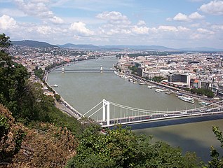
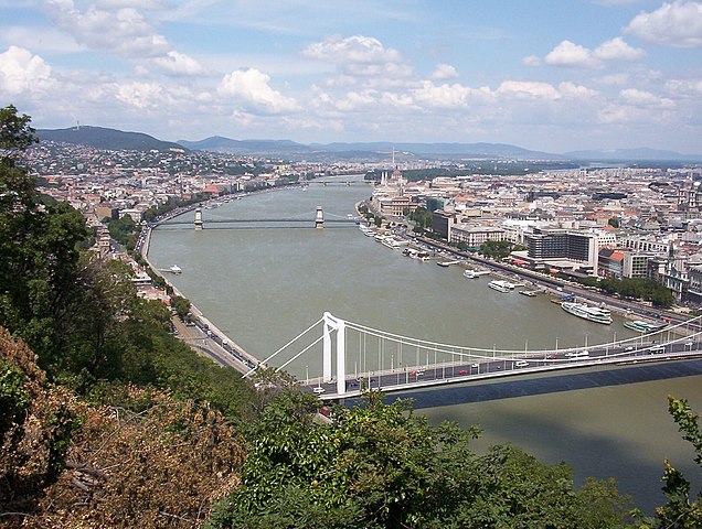
| Description | The Hungarian capital city of Budapest, from Gellért Hill. Approximate elevation: 160 m. |
| Data | 12:53+02 (Europe/Budapest) |
| Origine | Obra proprie |
| Autor | Gabor Eszes (UED77) |
| Permission (Reuso de iste file) |
Use it freely. |
| Camera location | | View this and other nearby images on: OpenStreetMap |
|---|
Io, titular del derecto de autor sur iste obra, declara de publicar lo sub le sequente licentias:

|
Le permission es concedite de copiar, distribuer e/o modificar iste documento sub le conditiones del Licentia GNU pro Documentation Libere, Version 1.2 o omne version plus recente publicate per le Fundation pro Software Libere; sin Sectiones Invariabile, sin Textos de Copertura Frontal e sin Textos de Copertura Posterior. Un copia del licentia es includite in le section titulate Licentia GNU pro Documentation Libere. |
| Iste file es disponibile sub le licentia Creative Commons Attribution-CompartiSimile 3.0 Non-localisate. | ||
| ||
| Iste etiquetta de licentia esseva addite a iste file como parte del actualisation del licentia GFDL. |
Iste file es disponibile sub le licentias Creative Commons Attribution-Share Alike 2.5 Generic, 2.0 Generic e 1.0 Generic.
- Tu es libere:
- de condivider – de copiar, distribuer e transmitter le obra
- de remixar – de adaptar le obra
- Sub le sequente conditiones:
- attribution – Tu debe dar information appropriate sur le autor, fornir un ligamine al licentia, e indicar si modificationes ha essite apportate. Tu pote facer lo de qualcunque maniera rationabile, ma non in alcun modo que suggere que le licentiator approba te o tu uso del obra.
- condivider equalmente – Si tu altera, transforma o disveloppa le material, tu debe distribuer tu contributiones sub un licentia identic o compatibile con le original.
Tu pote seliger le licentia de tu preferentia.
|
Historia del file
Clicca sur un data/hora pro vider le file como appareva a ille tempore.
| Data/Hora | Miniatura | Dimensiones | Usator | Commento | |
|---|---|---|---|---|---|
| actual | 03:52, 3 januario 2006 | | 1 632 × 1 232 (374 KB) | UED77 | {{Information |Description =The Hungarian capital city of Budapest, from Gellért Hill. Taken from approximately 47°29′16.13″ N 19°02′49.20″ E, facing approximately 350°. Approximate elevation: 160 m. |Source =Own work. |Date =2004-07-13 12:53+ |
Uso de iste file
Le sequente pagina usa iste file:
Uso global de iste file
Le altere wikis sequente usa iste imagine:
- Uso in ang.wikipedia.org
- Uso in an.wikipedia.org
- Uso in arz.wikipedia.org
- Uso in ast.wikipedia.org
- Uso in av.wikipedia.org
- Uso in az.wikipedia.org
- Uso in ba.wikipedia.org
- Uso in be.wikipedia.org
- Uso in br.wikipedia.org
- Uso in ca.wikipedia.org
- Uso in ceb.wikipedia.org
- Uso in ce.wikipedia.org
- Uso in crh.wikipedia.org
- Uso in cs.wikipedia.org
- Uso in cv.wikipedia.org
- Uso in cy.wikipedia.org
- Uso in da.wikipedia.org
- Uso in de.wikipedia.org
- Uso in diq.wikipedia.org
- Uso in el.wikipedia.org
- Uso in en.wikipedia.org
- Uso in en.wikivoyage.org
- Uso in es.wikipedia.org
- Uso in eu.wikipedia.org
- Uso in fi.wikipedia.org
- Uso in fr.wiktionary.org
- Uso in ga.wikipedia.org
- Uso in gl.wikipedia.org
- Uso in he.wikipedia.org
- Uso in hr.wikipedia.org
- Uso in incubator.wikimedia.org
- Uso in inh.wikipedia.org
- Uso in io.wikipedia.org
- Uso in is.wikipedia.org
- Uso in it.wikipedia.org
- Uso in ja.wikipedia.org
Vider altere usos global de iste file.