
File:Baltic Sea map2.png

Dimension de iste previsualisation: 332 × 599 pixels.Altere resolutiones: 133 × 240 pixels | 266 × 480 pixels | 426 × 768 pixels | 567 × 1 024 pixels | 1 488 × 2 684 pixels.
File original (1 488 × 2 684 pixels, dimension del file: 1,25 MB, typo MIME: image/png)
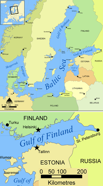
| Description | Map of the Baltic Sea. Created by NormanEinstein, May 25, 2006. |
| Data | (UTC) |
| Origine | |
| Autor |
|
Io, titular del derecto de autor sur iste obra, declara de publicar lo sub le sequente licentias:
| Iste file es disponibile sub le licentia Creative Commons Attribution-CompartiSimile 3.0 Non-localisate. | ||
| ||
| Iste etiquetta de licentia esseva addite a iste file como parte del actualisation del licentia GFDL. |

|
Le permission es concedite de copiar, distribuer e/o modificar iste documento sub le conditiones del Licentia GNU pro Documentation Libere, Version 1.2 o omne version plus recente publicate per le Fundation pro Software Libere; sin Sectiones Invariabile, sin Textos de Copertura Frontal e sin Textos de Copertura Posterior. Un copia del licentia es includite in le section titulate Licentia GNU pro Documentation Libere. |
Tu pote seliger le licentia de tu preferentia.
Registro de incargamento original
This image is a derivative work of the following images:
- File:Baltic_Sea_map.png licensed with Cc-by-sa-3.0-migrated, GFDL
- 2008-10-01T12:04:01Z Salleman 1500x1606 (822984 Bytes) added dots to Malmö and a ring to Luleå as per Åland, Öland and Rügen having their diacritics
- 2006-05-25T15:47:12Z NormanEinstein 1500x1606 (822600 Bytes) Map of the Baltic Sea. Created by NormanEinstein, May 25, 2006. {{GFDL-self}} [[Category:Maps of seas]]
Uploaded with derivativeFX
derivative works
Derivative works of this file: Baltic Sea map2 hr.svg
Historia del file
Clicca sur un data/hora pro vider le file como appareva a ille tempore.
| Data/Hora | Miniatura | Dimensiones | Usator | Commento | |
|---|---|---|---|---|---|
| actual | 08:02, 25 junio 2010 | | 1 488 × 2 684 (1,25 MB) | Materialscientist | {{Information |Description=Map of the Baltic Sea. Created by NormanEinstein, May 25, 2006. |Source=*File:Baltic_Sea_map.png |Date=2010-06-25 08:00 (UTC) |Author=*NormanEinstein: user:NormanEinstein *derivative work: ~~ |
Uso de iste file
Le sequente pagina usa iste file:
Uso global de iste file
Le altere wikis sequente usa iste imagine:
- Uso in azb.wikipedia.org
- Uso in bg.wikipedia.org
- Uso in bn.wikipedia.org
- Uso in bs.wikipedia.org
- Uso in en.wikipedia.org
- Uso in fr.wikipedia.org
- Uso in hi.wikipedia.org
- Uso in hr.wikipedia.org
- Uso in hy.wikipedia.org
- Uso in io.wikipedia.org
- Uso in it.wikipedia.org
- Uso in ja.wikipedia.org
- Uso in kk.wikipedia.org
- Uso in mr.wikipedia.org
- Uso in ms.wikipedia.org
- Uso in pa.wikipedia.org
- Uso in sl.wikipedia.org
- Uso in sq.wikipedia.org
- Uso in ta.wikipedia.org
- Uso in vi.wikipedia.org
- Uso in vls.wikipedia.org