
File:Atilax paludinosus range map.png
Non disponibile in resolution plus alte.
Atilax_paludinosus_range_map.png (456 × 473 pixels, dimension del file: 18 KB, typo MIME: image/png)
Summario
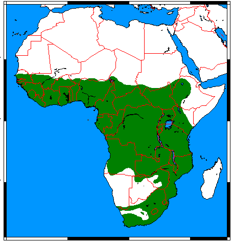
| Description |
English: Range map for Marsh Mongoose (Atilax paludinosus), made by me with help of www.aquarius.geomar.de, Map depending on the range map at IUCN red list. |
| Data | |
| Origine | Obra proprie |
| Autor | Udo Schröter |

|
This biogeographical map image could be re-created using vector graphics as an SVG file. This has several advantages; see Commons:Media for cleanup for more information. If an SVG form of this image is available, please upload it and afterwards replace this template with
{{vector version available|new image name}}.
It is recommended to name the SVG file “Atilax paludinosus range map.svg”—then the template Vector version available (or Vva) does not need the new image name parameter. |
Licentia
Io, titular del derecto de autor sur iste obra, declara de publicar lo sub le sequente licentias:
Iste file es disponibile sub le licentias Creative Commons Attribution-Share Alike 3.0 Unported, 2.5 Generic, 2.0 Generic e 1.0 Generic.
- Tu es libere:
- de condivider – de copiar, distribuer e transmitter le obra
- de remixar – de adaptar le obra
- Sub le sequente conditiones:
- attribution – Tu debe dar information appropriate sur le autor, fornir un ligamine al licentia, e indicar si modificationes ha essite apportate. Tu pote facer lo de qualcunque maniera rationabile, ma non in alcun modo que suggere que le licentiator approba te o tu uso del obra.
- condivider equalmente – Si tu altera, transforma o disveloppa le material, tu debe distribuer tu contributiones sub un licentia identic o compatibile con le original.

|
Le permission es concedite de copiar, distribuer e/o modificar iste documento sub le conditiones del Licentia GNU pro Documentation Libere, Version 1.2 o omne version plus recente publicate per le Fundation pro Software Libere; sin Sectiones Invariabile, sin Textos de Copertura Frontal e sin Textos de Copertura Posterior. Un copia del licentia es includite in le section titulate Licentia GNU pro Documentation Libere. |
Tu pote seliger le licentia de tu preferentia.
Historia del file
Clicca sur un data/hora pro vider le file como appareva a ille tempore.
| Data/Hora | Miniatura | Dimensiones | Usator | Commento | |
|---|---|---|---|---|---|
| actual | 01:07, 18 martio 2018 | | 456 × 473 (18 KB) | Maphobbyist | Border updates: South Sudan, Eritrea and Lebanon added, Yemen united, the former Neutral Zone and Waalvisbai removed, and all border gaps filled. |
| 22:51, 16 martio 2018 |  | 333 × 363 (14 KB) | Maphobbyist | South Sudan border | |
| 18:30, 28 julio 2011 |  | 294 × 341 (19 KB) | Craig Pemberton | Crop to original size. | |
| 18:30, 28 julio 2011 |  | 379 × 450 (25 KB) | Craig Pemberton | Normalize with other range maps for eventual combination in parent taxa. | |
| 13:50, 24 april 2009 |  | 456 × 473 (20 KB) | Nordelch | {{Information |Description={{en|1=Range map for Marsh Mongoose (''Atilax paludinosus''), made by me with help of [http://www.aquarius.geomar.de/omc_intro.html www.aquarius.geomar.de], Map depending on the [http://www.iucnredlist.org/details/41590 range ma |
Uso de iste file
Il non ha paginas que usa iste file.
Uso global de iste file
Le altere wikis sequente usa iste imagine:
- Uso in af.wikipedia.org
- Uso in ar.wikipedia.org
- Uso in arz.wikipedia.org
- Uso in avk.wikipedia.org
- Uso in azb.wikipedia.org
- Uso in bg.wikipedia.org
- Uso in br.wikipedia.org
- Uso in ca.wikipedia.org
- Uso in ceb.wikipedia.org
- Uso in de.wikipedia.org
- Uso in el.wikipedia.org
- Uso in en.wikipedia.org
- Uso in es.wikipedia.org
- Uso in eu.wikipedia.org
- Uso in fa.wikipedia.org
- Uso in fr.wikipedia.org
- Uso in he.wikipedia.org
- Uso in hu.wikipedia.org
- Uso in id.wikipedia.org
- Uso in it.wikipedia.org
- Uso in ko.wikipedia.org
- Uso in mhr.wikipedia.org
- Uso in pl.wikipedia.org
- Uso in pnb.wikipedia.org
- Uso in ru.wikipedia.org
- Uso in sq.wikipedia.org
- Uso in sv.wikipedia.org
- Uso in tr.wikipedia.org
- Uso in uk.wikipedia.org
- Uso in vi.wikipedia.org
- Uso in www.wikidata.org
- Uso in zh.wikipedia.org