
File:Administrative Districts of Germany 1981-2008.svg

Dimension de iste previsualisation PNG de iste file SVG: 439 × 599 pixels. Altere resolutiones: 176 × 240 pixels | 352 × 480 pixels | 563 × 768 pixels | 750 × 1 024 pixels | 1 500 × 2 048 pixels | 1 351 × 1 844 pixels.
File original (File SVG, dimensiones nominal: 1 351 × 1 844 pixels, grandor del file: 1,39 MB)
Summario
| Description |
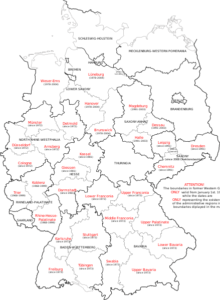
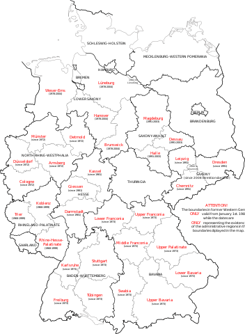
English: Map of Germany showing the boundaries of the Regierungsbezirke for FRG from January 1st 1981 and for Germany till 2008. Also displayed are the former RB of Lower Saxony, Rhineland-Palatinate and Saxony-Anhalt. |
| Data | |
| Origine | Own work, map translated from Image:Regierungsbezirke_Deutschlands_1981-2008.svg |
| Autor | Bennet Schulte |
Licentia
Io, titular del derecto de autor sur iste obra, declara de publicar lo sub le sequente licentias:
Iste file es disponibile sub le licentia Creative Commons Attribution-CompartiSimile 3.0 Non-localisate.
- Tu es libere:
- de condivider – de copiar, distribuer e transmitter le obra
- de remixar – de adaptar le obra
- Sub le sequente conditiones:
- attribution – Tu debe dar information appropriate sur le autor, fornir un ligamine al licentia, e indicar si modificationes ha essite apportate. Tu pote facer lo de qualcunque maniera rationabile, ma non in alcun modo que suggere que le licentiator approba te o tu uso del obra.
- condivider equalmente – Si tu altera, transforma o disveloppa le material, tu debe distribuer tu contributiones sub un licentia identic o compatibile con le original.

|
Le permission es concedite de copiar, distribuer e/o modificar iste documento sub le conditiones del Licentia GNU pro Documentation Libere, Version 1.2 o omne version plus recente publicate per le Fundation pro Software Libere; sin Sectiones Invariabile, sin Textos de Copertura Frontal e sin Textos de Copertura Posterior. Un copia del licentia es includite in le section titulate Licentia GNU pro Documentation Libere. |
Tu pote seliger le licentia de tu preferentia.
Historia del file
Clicca sur un data/hora pro vider le file como appareva a ille tempore.
| Data/Hora | Miniatura | Dimensiones | Usator | Commento | |
|---|---|---|---|---|---|
| actual | 14:33, 1 octobre 2009 | | 1 351 × 1 844 (1,39 MB) | Exec | Neuhaus again |
| 14:29, 1 octobre 2009 |  | 1 351 × 1 844 (1,39 MB) | Exec | adding fact of Neuhaus | |
| 13:59, 30 septembre 2009 |  | 1 351 × 1 844 (1,39 MB) | Exec | another translation error solved | |
| 13:56, 30 septembre 2009 |  | 1 351 × 1 844 (1,39 MB) | Exec | translation error solved | |
| 13:50, 30 septembre 2009 |  | 1 351 × 1 844 (1,39 MB) | Exec | {{Information |Description={{en|1=Map of Germany showing the boundaries of the Regierungsbezirke for FRG from January 1st 1981 and for Germany till 2008. Also displayed are the former RB of Lower Saxony, Rhineland-Palatinate and Saxony-Anhalt.}} |Source={ |
Uso de iste file
Le sequente pagina usa iste file:
Uso global de iste file
Le altere wikis sequente usa iste imagine:
- Uso in ca.wikipedia.org
- Uso in en.wikipedia.org
- Uso in et.wikipedia.org
- Uso in fr.wikipedia.org
- Uso in fy.wikipedia.org
- Uso in gv.wikipedia.org
- Uso in ku.wikipedia.org
- Uso in ms.wikipedia.org
- Uso in th.wikipedia.org
- Uso in uk.wikipedia.org
- Uso in www.wikidata.org
- Uso in zh.wikipedia.org