
File:Abbasid Caliphate 850AD.png
Dimension de iste previsualisation: 800 × 497 pixels.Altere resolutiones: 320 × 199 pixels | 640 × 398 pixels | 1 024 × 637 pixels | 1 280 × 796 pixels | 2 163 × 1 345 pixels.
File original (2 163 × 1 345 pixels, dimension del file: 798 KB, typo MIME: image/png)
Summario
| Description |
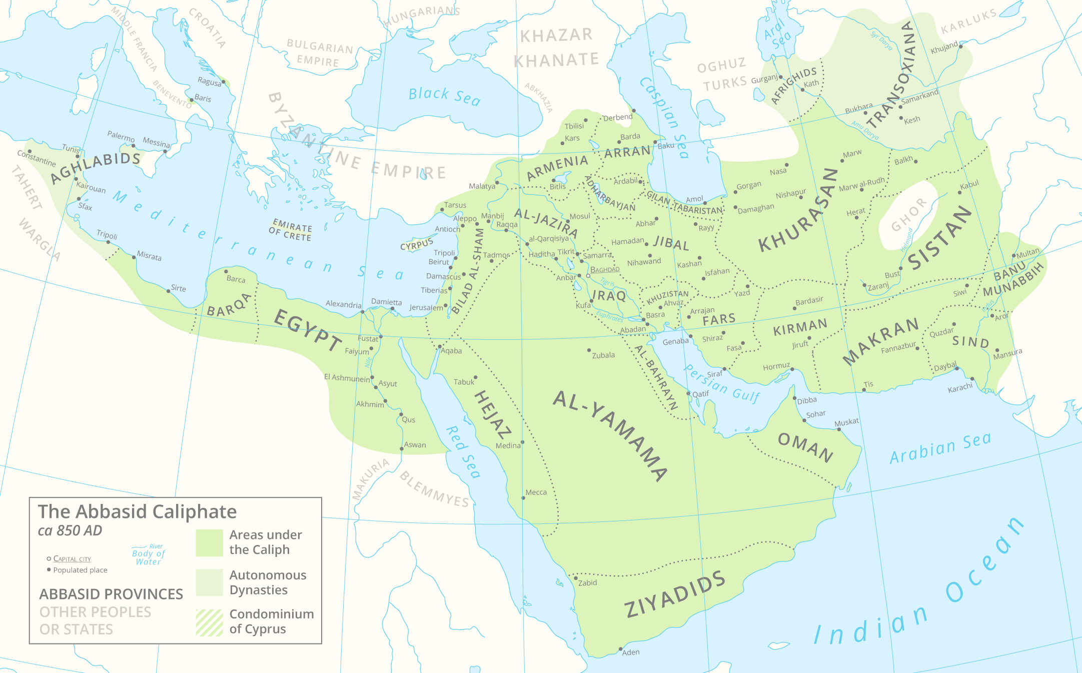
English: A map of the Abbasid Caliphate around 850 AD featuring provinces and settlements. |
| Data | |
| Origine |
Obra proprie.
This PNG graphic was created with Adobe Illustrator. |
| Autor | Cattette |
| Altere versiones | العربيَّة |
Licentia
Io, titular del derecto de autor sur iste obra, declara de publicar lo sub le sequente licentia:
Iste file es disponibile sub le licentia Creative Commons Attribution 4.0 International.
- Tu es libere:
- de condivider – de copiar, distribuer e transmitter le obra
- de remixar – de adaptar le obra
- Sub le sequente conditiones:
- attribution – Tu debe dar information appropriate sur le autor, fornir un ligamine al licentia, e indicar si modificationes ha essite apportate. Tu pote facer lo de qualcunque maniera rationabile, ma non in alcun modo que suggere que le licentiator approba te o tu uso del obra.
Historia del file
Clicca sur un data/hora pro vider le file como appareva a ille tempore.
| Data/Hora | Miniatura | Dimensiones | Usator | Commento | |
|---|---|---|---|---|---|
| actual | 13:05, 29 martio 2021 | | 2 163 × 1 345 (798 KB) | Cattette | Tweaked provinces, added Arabia |
| 08:13, 17 martio 2021 |  | 2 163 × 1 052 (691 KB) | Cattette | Tweaked provinces | |
| 12:05, 16 martio 2021 |  | 2 163 × 1 052 (690 KB) | Cattette | More provinces | |
| 06:10, 15 martio 2021 |  | 2 163 × 1 052 (666 KB) | Cattette | Added more cities, removed the Canal of the Pharaohs, added more divisions | |
| 21:48, 10 martio 2021 |  | 2 105 × 1 052 (508 KB) | Cattette | Uploaded own work with UploadWizard |
Uso de iste file
Le sequente pagina usa iste file:
Uso global de iste file
Le altere wikis sequente usa iste imagine:
- Uso in ar.wikipedia.org
- Uso in ast.wikipedia.org
- Uso in az.wikipedia.org
- Uso in bn.wikipedia.org
- Uso in ca.wikipedia.org
- Uso in cs.wikipedia.org
- Uso in de.wikipedia.org
- Uso in diq.wikipedia.org
- Uso in el.wikipedia.org
- Uso in en.wikipedia.org
- Uso in es.wikipedia.org
- Uso in eu.wikipedia.org
- Uso in fa.wikipedia.org
- Uso in fi.wikipedia.org
- Uso in ga.wikipedia.org
- Uso in gl.wikipedia.org
- Uso in ha.wikipedia.org
- Uso in ko.wikipedia.org
- Uso in lt.wikipedia.org
- Uso in lv.wikipedia.org
- Uso in mg.wikipedia.org
- Uso in mn.wikipedia.org
- Uso in ms.wikipedia.org
- Uso in pnb.wikipedia.org
- Uso in pt.wikipedia.org
- Uso in ro.wikipedia.org
- Uso in shi.wikipedia.org
- Uso in sq.wikipedia.org
- Uso in ta.wikipedia.org
- Uso in th.wikipedia.org
- Uso in tr.wikipedia.org
- Uso in uk.wikipedia.org
- Uso in ur.wikipedia.org
Vider altere usos global de iste file.