
File:PonticKingdom.png

Dimension de iste previsualisation: 718 × 600 pixels.Altere resolutiones: 287 × 240 pixels | 575 × 480 pixels | 919 × 768 pixels | 1 226 × 1 024 pixels | 1 551 × 1 296 pixels.
File original (1 551 × 1 296 pixels, dimension del file: 265 KB, typo MIME: image/png)
Summario

|
This historical map image could be re-created using vector graphics as an SVG file. This has several advantages; see Commons:Media for cleanup for more information. If an SVG form of this image is available, please upload it and afterwards replace this template with
{{vector version available|new image name}}.
It is recommended to name the SVG file “PonticKingdom.svg”—then the template Vector version available (or Vva) does not need the new image name parameter. |
| Description |
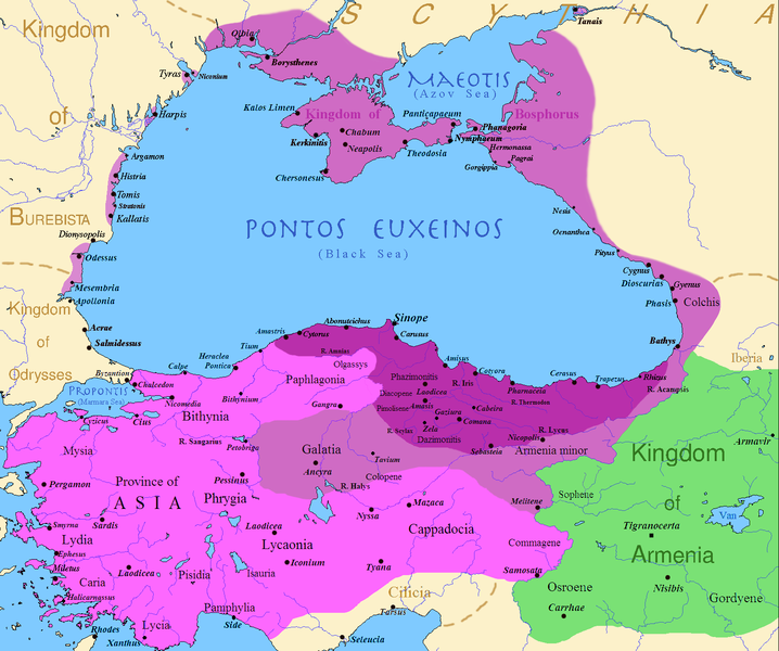
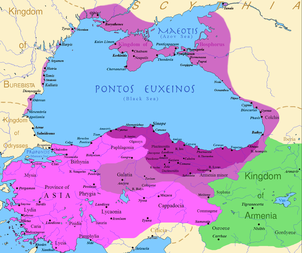
English: Map of the Kingdom of Pontus
Before the reign of Mithridates VI After his conquests His conquests in the first Mithridatic wars ; little adds (ancient shorelines & some greek colonies under Mithridate's rule) according with V. Yanko-Hombach, A.S. Gilbert, N. Panin, P. M. Dolukhanov: The Black Sea Flood Question: Changes in Coastline, Climate, and Human Settlement, Springer, Netherlands, 2007, and with Appianus, Plutarchus & Strabo. |
| Data | |
| Origine | I (Javierfv1212 (talk)) created this work entirely by myself. Sources, Cambridge Ancient history volume 9, Penguin atlas of Greek history and the Foreign Policy of Mithridates VI Eupator. |
| Autor | Javierfv1212 (talk) |
Licentia
| Iste obra ha essite liberate al dominio public per su autor, Javierfv1212 at anglese Wikipedia. Isto vale in tote le mundo. In alcun paises isto pote non esser legalmente possibile. In tal caso: Javierfv1212 concede a omnes le derecto de usar iste obra pro non importa qual fin, sin conditiones, a minus que tal conditiones sia requirite per lege. |
Registro de incargamento original
Transferred from en.wikipedia to Commons by Falcorian using CommonsHelper.
The original description page was here. All following user names refer to en.wikipedia.
- 2009-07-19 23:42 Javierfv1212 1551×1296× (205182 bytes) {{Information |Description = Map of the Kingdom of Pontus, Before the reign of mithridates VI (darkest purple), after his conquests (purple), and his conquests in the first Mithridatic wars (pink). |Source = I (~~~) created this work entirel
Historia del file
Clicca sur un data/hora pro vider le file como appareva a ille tempore.
| Data/Hora | Miniatura | Dimensiones | Usator | Commento | |
|---|---|---|---|---|---|
| actual | 02:00, 9 decembre 2017 | | 1 551 × 1 296 (265 KB) | SteinsplitterBot | Bot: Image rotated by 90° |
| 00:00, 9 decembre 2017 |  | 1 296 × 1 551 (316 KB) | SteinsplitterBot | Bot: Image rotated by 270° | |
| 17:54, 22 septembre 2016 |  | 1 551 × 1 296 (265 KB) | Hohum | Lighten water area | |
| 11:21, 9 augusto 2016 |  | 1 551 × 1 296 (260 KB) | MAXHO | Details : more cities & shoreline of this time | |
| 20:57, 1 octobre 2015 |  | 1 551 × 1 296 (249 KB) | Spiridon Ion Cepleanu | Cosmetic again | |
| 12:55, 30 septembre 2015 |  | 1 551 × 1 296 (247 KB) | Spiridon Ion Cepleanu | Cosmetic colours & background names | |
| 14:21, 7 april 2014 |  | 1 551 × 1 296 (225 KB) | Spiridon Ion Cepleanu | Little changes (ancient shoreline & some greek colonies under Pontic rule) according with V. Yanko-Hombach, A.S. Gilbert, N. Panin, P. M. Dolukhanov: ''The Black Sea Flood Question: Changes in Coastline, Climate, and Human Settlement'', Springer, Nethe... | |
| 04:14, 20 julio 2009 |  | 1 551 × 1 296 (200 KB) | File Upload Bot (Magnus Manske) | {{BotMoveToCommons|en.wikipedia|year={{subst:CURRENTYEAR}}|month={{subst:CURRENTMONTHNAME}}|day={{subst:CURRENTDAY}}}} {{Information |Description={{en|Map of the Kingdom of Pontus, Before the reign of mithridates VI (darkest purple), after his conquests |
Uso de iste file
Le sequente pagina usa iste file:
Uso global de iste file
Le altere wikis sequente usa iste imagine:
- Uso in ar.wikipedia.org
- Uso in ast.wikipedia.org
- Uso in azb.wikipedia.org
- Uso in az.wikipedia.org
- Uso in bg.wikipedia.org
- Uso in br.wikipedia.org
- Uso in ca.wikipedia.org
- Uso in cs.wikipedia.org
- Uso in da.wikipedia.org
- Uso in de.wikipedia.org
- Uso in el.wikipedia.org
- Uso in en.wikipedia.org
- Uso in es.wikipedia.org
- Uso in et.wikipedia.org
- Uso in eu.wikipedia.org
- Uso in fa.wikipedia.org
- Uso in fr.wikipedia.org
Vider altere usos global de iste file.