
File:WWI.png
Dimension de iste previsualisation: 800 × 333 pixels.Altere resolutiones: 320 × 133 pixels | 640 × 266 pixels | 1 502 × 625 pixels.
File original (1 502 × 625 pixels, dimension del file: 52 KB, typo MIME: image/png)
Summario
| Description |
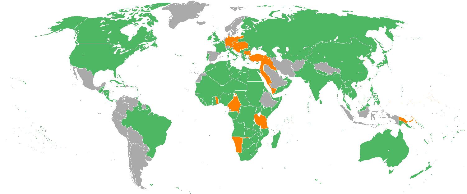
English: Map with the Participants in World War I:
Русский: Карта мира начала XX в. с границами альянсов:
Deutsch: Karte der Beteiligten des Ersten Weltkrieges:
|
| Data | 22 de decembre 2005 (original upload date) |
| Origine | Transferred from en.wikipedia to Commons. |
| Autor | Helmandsare, Joaopais, El Jaber, Aivazovsky + Various (Vide infra.) |
| Altere versiones |
|


|
This military map image could be re-created using vector graphics as an SVG file. This has several advantages; see Commons:Media for cleanup for more information. If an SVG form of this image is available, please upload it and afterwards replace this template with
{{vector version available|new image name}}.
It is recommended to name the SVG file “WWI.svg”—then the template Vector version available (or Vva) does not need the new image name parameter. |
Licentia
Aivazovsky at the English Wikipedia, titular del derecto de autor sur iste obra, declara de publicar lo sub le sequente licentia:

|
Le permission es concedite de copiar, distribuer e/o modificar iste documento sub le conditiones del Licentia GNU pro Documentation Libere, Version 1.2 o omne version plus recente publicate per le Fundation pro Software Libere; sin Sectiones Invariabile, sin Textos de Copertura Frontal e sin Textos de Copertura Posterior. Un copia del licentia es includite in le section titulate Licentia GNU pro Documentation Libere. |
| Iste file es disponibile sub le licentia Creative Commons Attribution-CompartiSimile 3.0 Non-localisate. | ||
| Attribution: Aivazovsky at the English Wikipedia | ||
| ||
| Iste etiquetta de licentia esseva addite a iste file como parte del actualisation del licentia GFDL. |
Registro de incargamento original
The original description page was here. All following user names refer to en.wikipedia.
- 2007-02-14 15:32 Aivazovsky 1357×628×8 (30657 bytes) Fixed northern islands of Russia and Norway, fixed borders of Russia's South Caucasus territory
- 2006-05-02 21:54 Helmandsare 1357×628×8 (30663 bytes)
- 2006-01-19 19:34 Joaopais 1357×628×8 (30415 bytes)
- 2006-01-15 12:12 El Jaber 1357×628×8 (45477 bytes) Map with the [[Participants in World War I]]: * <font color="green">''Green''</font>: [[Allies of World War I|Allies]] * <font color="red">''Red''</font>: [[Central Powers]] * <font color="yellow">''Yellow''</font>: [[Neutral Country|Neutral Countries]]
- 2005-12-22 00:53 Joaopais 1357×628×8 (30366 bytes) added Belize and the Guyanas (at the time British and French colonies)
- 2005-12-22 00:19 Joaopais 1357×628×8 (30365 bytes) Map with the [[Participants in World War I]]: * <font color="green">''Green''</font>: [[Allies of World War I|Allies]] * <font color="orange">''Orange''</font>: [[Axis Powers]]
Historia del file
Clicca sur un data/hora pro vider le file como appareva a ille tempore.
| Data/Hora | Miniatura | Dimensiones | Usator | Commento | |
|---|---|---|---|---|---|
| actual | 18:19, 27 februario 2014 | | 1 502 × 625 (52 KB) | Grachifan | major update |
| 18:18, 27 februario 2014 |  | 1 502 × 625 (60 KB) | Grachifan | major update | |
| 18:17, 27 februario 2014 |  | 1 502 × 625 (54 KB) | Grachifan | major update | |
| 03:28, 31 martio 2013 |  | 1 357 × 628 (45 KB) | OgreBot | (BOT): Reverting to most recent version before archival | |
| 03:28, 31 martio 2013 |  | 1 357 × 628 (30 KB) | OgreBot | (BOT): Uploading old version of file from en.wikipedia; originally uploaded on 2006-05-02 21:54:27 by Helmandsare | |
| 03:27, 31 martio 2013 |  | 1 357 × 628 (30 KB) | OgreBot | (BOT): Uploading old version of file from en.wikipedia; originally uploaded on 2006-01-19 19:34:32 by Joaopais | |
| 03:27, 31 martio 2013 |  | 1 357 × 628 (44 KB) | OgreBot | (BOT): Uploading old version of file from en.wikipedia; originally uploaded on 2006-01-15 12:12:07 by El Jaber | |
| 03:27, 31 martio 2013 |  | 1 357 × 628 (30 KB) | OgreBot | (BOT): Uploading old version of file from en.wikipedia; originally uploaded on 2005-12-22 00:53:03 by Joaopais | |
| 03:27, 31 martio 2013 |  | 1 357 × 628 (30 KB) | OgreBot | (BOT): Uploading old version of file from en.wikipedia; originally uploaded on 2005-12-22 00:19:12 by Joaopais | |
| 23:42, 4 januario 2013 |  | 1 357 × 628 (45 KB) | Tfts | marked Albania as a neutral state |
Uso de iste file
Il non ha paginas que usa iste file.
Uso global de iste file
Le altere wikis sequente usa iste imagine:
- Uso in als.wikipedia.org
- Uso in ar.wikipedia.org
- Uso in az.wikipedia.org
- Uso in be.wikipedia.org
- Uso in bg.wikipedia.org
- Uso in ca.wikipedia.org
- Uso in ceb.wikipedia.org
- Uso in ce.wikipedia.org
- Uso in da.wikipedia.org
- Uso in de.wikipedia.org
- Uso in en.wikipedia.org
- Uso in eo.wikipedia.org
- Uso in es.wikipedia.org
- Uso in eu.wikipedia.org
- Uso in fy.wikipedia.org
- Uso in he.wikipedia.org
- Uso in hr.wikipedia.org
- Uso in hsb.wikipedia.org
- Uso in hy.wikipedia.org
- Uso in id.wikipedia.org
- Uso in ja.wikipedia.org
- Uso in kk.wikipedia.org
- Uso in ko.wikipedia.org
- Uso in la.wikipedia.org
- Uso in lld.wikipedia.org
- Uso in ms.wikipedia.org
- Uso in nds.wikipedia.org
- Uso in nl.wikipedia.org
- Uso in pa.wikipedia.org
- Uso in pl.wikipedia.org
- Uso in pt.wikipedia.org
- Uso in ro.wikipedia.org
- Uso in ru.wikipedia.org
- Uso in sh.wikipedia.org
Vider altere usos global de iste file.