
File:Netherlands Map (Without Islands).svg

Dimension de iste previsualisation PNG de iste file SVG: 506 × 600 pixels. Altere resolutiones: 202 × 240 pixels | 405 × 480 pixels | 648 × 768 pixels | 864 × 1 024 pixels | 1 727 × 2 048 pixels | 743 × 881 pixels.
File original (File SVG, dimensiones nominal: 743 × 881 pixels, grandor del file: 797 KB)
Summario
This W3C-unspecified vector image was created with Inkscape .
| Description |
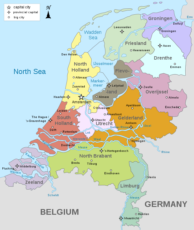
English: Map of the Netherlands, showing provinces, large cities, rivers and lakes (without the Caribbean Netherlands).
Deutsch: Karte der Niederlande, mit die Provinzen, die Großstädte, die Flüsse und der Seen (ohne die Karibische Niederlande). |
| Data | |
| Origine | Obra proprie |
| Autor | Alphathon |
| Altere versiones |
[]
|


.svg)
.svg)
Licentia
Io, titular del derecto de autor sur iste obra, declara de publicar lo sub le sequente licentias:
Iste file es disponibile sub le licentia Creative Commons Attribution-CompartiSimile 3.0 Non-localisate.
- Tu es libere:
- de condivider – de copiar, distribuer e transmitter le obra
- de remixar – de adaptar le obra
- Sub le sequente conditiones:
- attribution – Tu debe dar information appropriate sur le autor, fornir un ligamine al licentia, e indicar si modificationes ha essite apportate. Tu pote facer lo de qualcunque maniera rationabile, ma non in alcun modo que suggere que le licentiator approba te o tu uso del obra.
- condivider equalmente – Si tu altera, transforma o disveloppa le material, tu debe distribuer tu contributiones sub un licentia identic o compatibile con le original.

|
Le permission es concedite de copiar, distribuer e/o modificar iste documento sub le conditiones del Licentia GNU pro Documentation Libere, Version 1.2 o omne version plus recente publicate per le Fundation pro Software Libere; sin Sectiones Invariabile, sin Textos de Copertura Frontal e sin Textos de Copertura Posterior. Un copia del licentia es includite in le section titulate Licentia GNU pro Documentation Libere. |
Tu pote seliger le licentia de tu preferentia.
Historia del file
Clicca sur un data/hora pro vider le file como appareva a ille tempore.
| Data/Hora | Miniatura | Dimensiones | Usator | Commento | |
|---|---|---|---|---|---|
| actual | 10:56, 13 april 2019 | | 743 × 881 (797 KB) | Thayts | Updated borders |
| 09:37, 15 octobre 2014 |  | 743 × 881 (872 KB) | Bibi Saint-Pol | Harmonising with other maps | |
| 23:44, 10 februario 2011 |  | 800 × 948 (1,4 MB) | Alphathon | {{Information |Description ={{en|1=Map of the provinces of the Netherlands (without islands)}} {{de|1=Karte der Provinzen der Niederlande}} |Source ={{own}} |Author =Alphathon |Date =2011-02-10 |Permission |
Uso de iste file
Le sequente pagina usa iste file:
Uso global de iste file
Le altere wikis sequente usa iste imagine:
- Uso in ar.wikipedia.org
- Uso in ban.wikipedia.org
- Uso in en.wikibooks.org
- Uso in es.wikibooks.org
- Uso in fi.wikipedia.org
- Uso in fr.wikibooks.org
- Uso in hu.wikipedia.org
- Uso in ja.wikipedia.org
- Uso in uk.wikipedia.org
- Uso in www.wikidata.org
.svg)