
File:Mississippi-Coast-towns-NOAA.jpg
Non disponibile in resolution plus alte.
Mississippi-Coast-towns-NOAA.jpg (750 × 382 pixels, dimension del file: 57 KB, typo MIME: image/jpeg)

|
This map image could be re-created using vector graphics as an SVG file. This has several advantages; see Commons:Media for cleanup for more information. If an SVG form of this image is available, please upload it and afterwards replace this template with
{{vector version available|new image name}}.
It is recommended to name the SVG file “Mississippi-Coast-towns-NOAA.svg”—then the template Vector version available (or Vva) does not need the new image name parameter. |


Summario
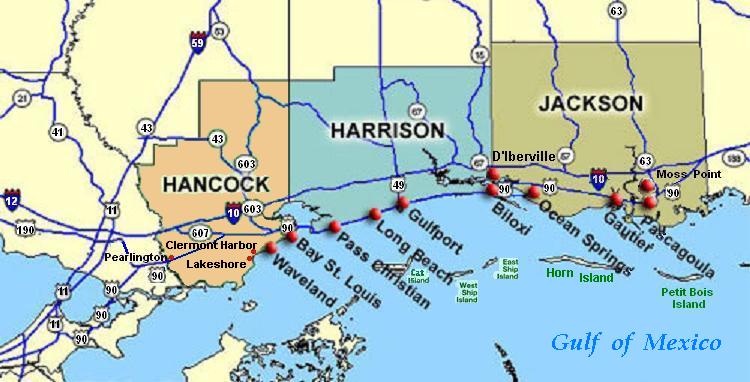
| Description | Coastal map of the U.S. state of Mississippi, showing major towns and cities in the three coastal counties: Hancock, Harrison, and Jackson County. Also shown are Cat Island, West Ship Island, East Ship Island, Horn Island and Petit Bois Island.The locations of towns, roads and offshore islands are based on NOAA and NASA maps. |
| Data | |
| Origine |
Obra proprie; self-made (hand-edited with MS-Paint)
Pure stupidity: The map is in quick JPEG format, for large display as highly readable, in about 20 articles that display the map. JPEG clarity is enhanced by painted areas behind many labels, causing the wording to be clearer than even a massive SVG or PNG-format file could provide, due to the sharp display contrast of JPEG files. JPEG Clarity: Even though JPEG images have artifacts, they can display clearer wording in small maps due to auto-contrast enhancement. The same painted/shaded areas, that illuminate wording, would make the map excessively gargantuan in slow cumbersome PNG or SVG format, as is the case with terrain maps, which also should NEVER be converted to massive PNG format. |
| Autor | Wikid77 |
Licentia
| Iste obra ha essite liberate al dominio public per su autor, I, Wikid77. Isto vale in tote le mundo. In alcun paises isto pote non esser legalmente possibile. In tal caso: I, Wikid77 concede a omnes le derecto de usar iste obra pro non importa qual fin, sin conditiones, a minus que tal conditiones sia requirite per lege. |
Historia del file
Clicca sur un data/hora pro vider le file como appareva a ille tempore.
| Data/Hora | Miniatura | Dimensiones | Usator | Commento | |
|---|---|---|---|---|---|
| actual | 02:54, 26 junio 2007 | | 750 × 382 (57 KB) | Wikid77 | Brown-toned map: Hancock County as tan (was green); put "Gulf of Mexico" Antigua font; shift labels on islands |
| 00:17, 26 junio 2007 |  | 750 × 382 (56 KB) | Wikid77 | Mississippi coastal map, with "Horn Island" relabeled, clarified Hwy "90" and "63" icons. | |
| 18:56, 21 junio 2007 |  | 750 × 382 (56 KB) | Wikid77 | re-load of image file, in case internal data was garbled | |
| 18:11, 21 junio 2007 |  | 750 × 382 (56 KB) | Wikid77 | {{Information |Description=Coastal map of the U.S. state of en:Mississippi, showing major towns and cities in the 3 coastal counties: Hancock, Harrison, a |
Uso de iste file
Il non ha paginas que usa iste file.
Uso global de iste file
Le altere wikis sequente usa iste imagine:
- Uso in ca.wikipedia.org
- Uso in de.wikipedia.org
- Uso in en.wikipedia.org
- Hancock County, Mississippi
- Pearlington, Mississippi
- Waveland, Mississippi
- Biloxi, Mississippi
- Gulfport, Mississippi
- Long Beach, Mississippi
- Gautier, Mississippi
- Ocean Springs, Mississippi
- Pascagoula Abduction
- Effects of Hurricane Katrina in Mississippi
- Ship Island
- Horn Island Chemical Warfare Service Quarantine Station
- Uso in fr.wikipedia.org
- Uso in fy.wikipedia.org
- Uso in he.wikipedia.org
- Uso in hu.wikipedia.org
- Uso in it.wikipedia.org
- Uso in ja.wikipedia.org
- Uso in pt.wikipedia.org
- Uso in tr.wikipedia.org
- Uso in vi.wikipedia.org
- Uso in zh.wikipedia.org