
File:Island of Ireland location map Dublin.svg

Dimension de iste previsualisation PNG de iste file SVG: 481 × 599 pixels. Altere resolutiones: 192 × 240 pixels | 385 × 480 pixels | 616 × 768 pixels | 822 × 1 024 pixels | 1 643 × 2 048 pixels | 1 450 × 1 807 pixels.
File original (File SVG, dimensiones nominal: 1 450 × 1 807 pixels, grandor del file: 642 KB)
| Description |
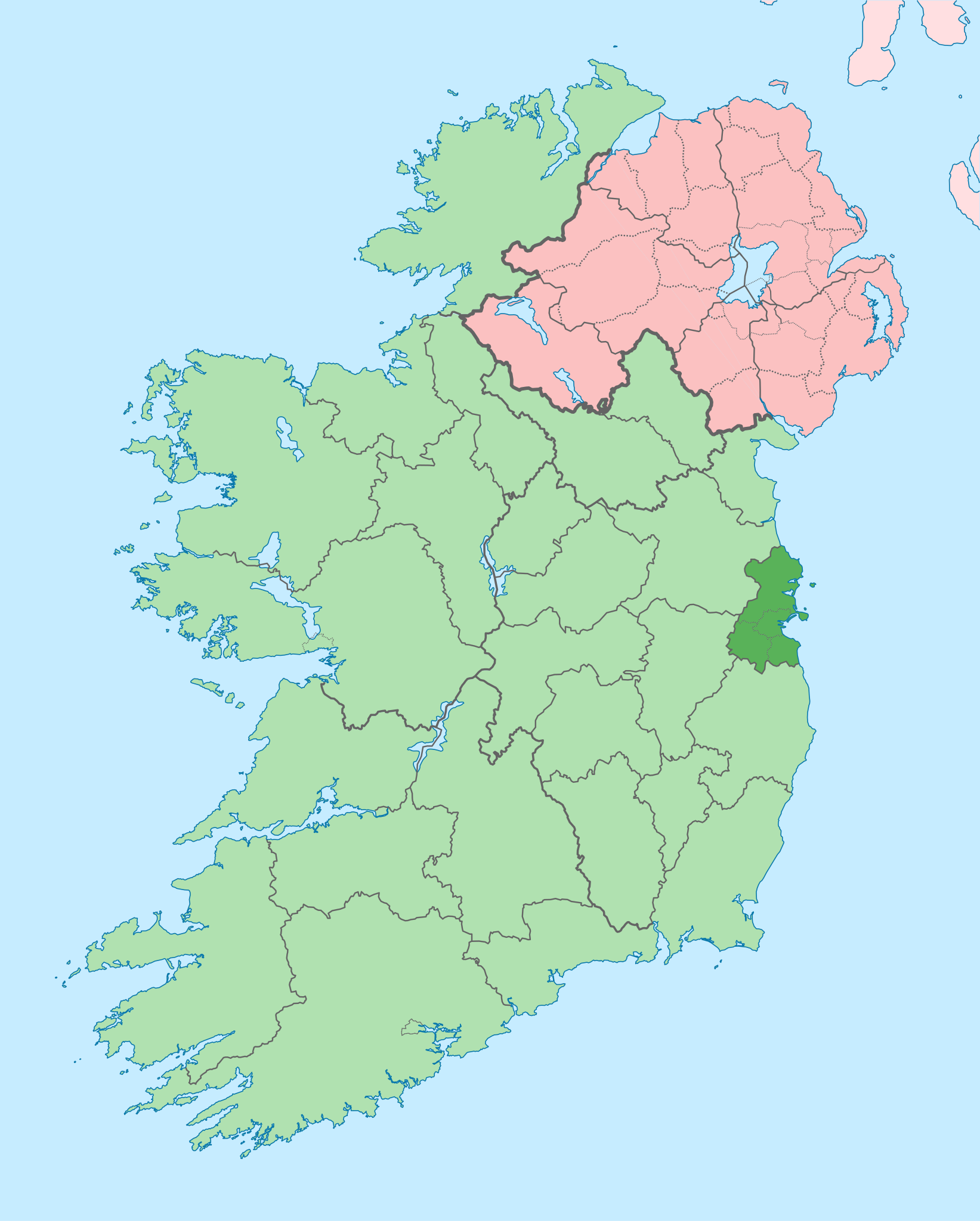
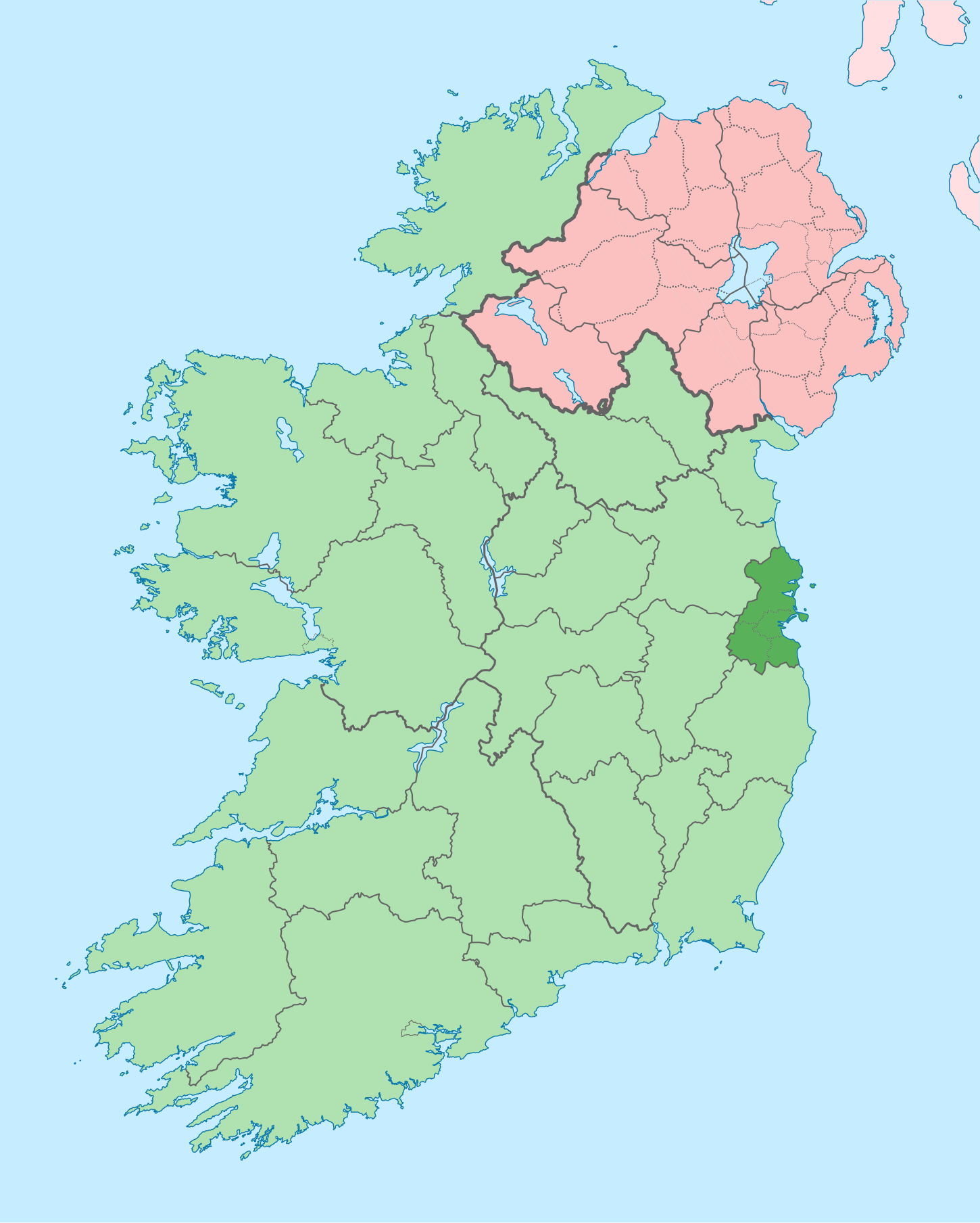
English: The island of Ireland, showing international border between Ireland and Northern Ireland, traditional provinces, traditional counties, and local authority areas in Ireland and Northern Ireland. |
| Data | (UTC) |
| Origine | |
| Autor |
|
| Altere versiones |
Derivative works of this file: |
| This is a retouched picture, which means that it has been digitally altered from its original version. Modifications: Coloured in regions with county of article highlighted. The original can be viewed here: Island of Ireland location map.svg:
|
Io, titular del derecto de autor sur iste obra, declara de publicar lo sub le sequente licentia:
Iste file es disponibile sub le licentia Creative Commons Attribution-CompartiSimile 3.0 Non localisate.
- Tu es libere:
- de condivider – de copiar, distribuer e transmitter le obra
- de remixar – de adaptar le obra
- Sub le sequente conditiones:
- attribution – Tu debe dar information appropriate sur le autor, fornir un ligamine al licentia, e indicar si modificationes ha essite apportate. Tu pote facer lo de qualcunque maniera rationabile, ma non in alcun modo que suggere que le licentiator approba te o tu uso del obra.
- condivider equalmente – Si tu altera, transforma o disveloppa le material, tu debe distribuer tu contributiones sub un licentia identic o compatibile con le original.
Registro de incargamento original
This image is a derivative work of the following images:
- File:Island_of_Ireland_location_map.svg licensed with Cc-by-sa-3.0
- 2010-03-06T20:43:33Z Rannpháirtí anaithnid 1450x1807 (679207 Bytes) Fix incorrectly coloured isands.
- 2010-03-03T22:19:29Z Rannpháirtí anaithnid 1450x1807 (679744 Bytes) {{Information |Description={{de|Positionskarte von [[:de:Irland|Irland]]}} Quadratische Plattkarte, N-S-Streckung 170 %. Geographische Begrenzung der Karte: * N: 55.6° N * S: 51.2° N * W: 11.0° W * O: 5.0° W {{en|Location
Uploaded with derivativeFX
Historia del file
Clicca sur un data/hora pro vider le file como appareva a ille tempore.
| Data/Hora | Miniatura | Dimensiones | Usator | Commento | |
|---|---|---|---|---|---|
| actual | 09:16, 3 julio 2020 | | 1 450 × 1 807 (642 KB) | Chipmunkdavis | Per the Local Government Reform Act 2014, joining both Tipperarys and both Waterfords (and removing Limerick City code). Colouring in islands, cleaning up and grouping code to remove stray objects and show Galway and Lough Ree. |
| 00:44, 19 julio 2010 |  | 1 450 × 1 807 (815 KB) | Mabuska | {{Information |Description={{en|The island of Ireland, showing international border between Northern Ireland and Republic of Ireland, traditional provinces, traditional counties, and local authority areas in the Republic of Ireland and Northern Ireland.}} |
Uso de iste file
Il non ha paginas que usa iste file.
Uso global de iste file
Le altere wikis sequente usa iste imagine:
- Uso in ar.wikipedia.org
- Uso in ast.wikipedia.org
- Uso in bg.wikipedia.org
- Uso in ca.wikipedia.org
- Uso in cs.wikipedia.org
- Uso in da.wikipedia.org
- Uso in en.wikipedia.org
- County Dublin
- Dublin
- Swords, Dublin
- Sydney Parade Avenue
- Northside, Dublin
- Southside, Dublin
- Merrion Centre, Dublin
- List of Ireland-related topics
- South Dublin
- Dún Laoghaire–Rathdown
- Fingal
- Template:County Dublin
- Tallaght
- List of Dublin postal districts
- Shenick Island
- Park Avenue, Dublin
- Kilmore West
- Greater Dublin Area
- Nutgrove
- Sutton Park, Dublin
- Man of War, Fingal
- Template:Dublin-geo-stub
- Heytesbury Street
- N32 road (Ireland)
- History of Belfast
- List of subdivisions of County Dublin
- North Wall, Dublin
- Sutton Creek (Ireland)
- Glenview, Tallaght
- Shandon, Dublin
- Ashtown Castle
- Red Gap
Vider altere usos global de iste file.