File:Byzantine Constantinople-en.png

Le contento del pagina non es supportate in altere linguas.
De Wikipedia, le encyclopedia libere

File original(3 200 × 2 888 pixels, dimension del file: 2,35 MB, typo MIME: image/png)

Iste file proveni de Wikimedia Commons e pote esser usate per altere projectos. Le description de su pagina de description ibi es monstrate in basso.

Wikipedia

 This is a featured picture on the English language Wikipedia (Featured pictures) and is considered one of the finest images. See its nomination here.

If you think this file should be featured on Wikimedia Commons as well, feel free to nominate it.
If you have an image of similar quality that can be published under a suitable copyright license, be sure to upload it, tag it, and nominate it.

Summario

Description
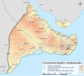
English: Topographical map of Constantinople during the Byzantine period.
Български: Топографска карта на Константинопол (Цариград) през византийския период. Източник: R. Janin, Constantinople Byzantine. Developpement urbain et repertoire topographique. Пътната мрежа и някои други детайли се основават на Dumbarton Oaks Papers 54 и други публикувани източници.
Deutsch: Topografische Karte Konstantinopels während des byzantinischen Zeitraums. Quelle: R. Janin, Constantinople Byzantine. Developpement urbain et repertoire topographique. Straßennetz und andere Einzelheiten basiert auf Dumbarton Oaks Papers 54. Kirchen, insb. nicht identifizierte und ausgegrabene Bauten sind aus dem The Byzantine Churches of Istanbul entnommen. Andere herausgegebenen Quellen wurden behilfsmäßig gebraucht.
Ελληνικά: Τοπογραφικός χάρτης Κωνσταντινουπόλεως κατά τη Βυζαντινή περίοδο. Βασική πηγή χάρτη: R. Janin, Constantinople Byzantine. Developpement urbain et repertoire topographique. Το οδικό δίκτυο και διάφορες άλλες λεπτομέρειες με βάση το Dumbarton Oaks Papers 54. Πληροφορίες για τις εκκλησίες, ιδιαίτερα τις μη ταυτοποιημένες, από την ιστοσελίδα The Byzantine Churches of Istanbul του Πανεπιστημίου της Νέας Υόρκης.
Although I've striven to make this map as complete and correct as possible, there may be some errors or omissions. Any corrections & suggestions are welcome.
Data
Origine

Own work using:

Autor Cplakidas
Permission
(Reuso de iste file)
Io, titular del derecto de autor sur iste obra, declara de publicar lo sub le sequente licentias:
w:ia:Creative Commons
attribution condivider equalmente
Iste file es disponibile sub le licentia Creative Commons Attribution-CompartiSimile 3.0 Non-localisate.
Tu es libere:
  • de condivider – de copiar, distribuer e transmitter le obra
  • de remixar – de adaptar le obra
Sub le sequente conditiones:
  • attribution – Tu debe dar information appropriate sur le autor, fornir un ligamine al licentia, e indicar si modificationes ha essite apportate. Tu pote facer lo de qualcunque maniera rationabile, ma non in alcun modo que suggere que le licentiator approba te o tu uso del obra.
  • condivider equalmente – Si tu altera, transforma o disveloppa le material, tu debe distribuer tu contributiones sub un licentia identic o compatibile con le original.
GNU head Le permission es concedite de copiar, distribuer e/o modificar iste documento sub le conditiones del Licentia GNU pro Documentation Libere, Version 1.2 o omne version plus recente publicate per le Fundation pro Software Libere; sin Sectiones Invariabile, sin Textos de Copertura Frontal e sin Textos de Copertura Posterior. Un copia del licentia es includite in le section titulate Licentia GNU pro Documentation Libere.
Tu pote seliger le licentia de tu preferentia.
Altere versiones

[modificar]

Full maps

SVG:

PNG:

Numeric versions

Regions

Roads

Open this image as an overlay in Google Earth (Google Maps, Bing) (Help|Source)

Legendas

Adde un explanation de un linea de lo que iste file representa
Constantinople during the Byzantine period

Objectos representate in iste file

representa

Alcun valor sin elemento Wikidata

copyrighted anglese

inception anglese

28 octobre 2008

media type anglese

image/png

checksum anglese

b4b5347456038e42cfa57b6c9763eaefb8d38a55

data size anglese

2 462 235 Byte

height anglese

2 888 pixel

width anglese

3 200 pixel

Historia del file

Clicca sur un data/hora pro vider le file como appareva a ille tempore.

Data/HoraMiniaturaDimensionesUsatorCommento
actual17:42, 25 april 2010Miniatura pro le version de 17:42, 25 april 20103 200 × 2 888 (2,35 MB)MahahahaneapneapCompressed
12:56, 15 decembre 2009Miniatura pro le version de 12:56, 15 decembre 20093 200 × 2 888 (3,42 MB)Cplakidaslarger & more detailed version, various corrections, Galata included
23:08, 30 junio 2009Miniatura pro le version de 23:08, 30 junio 20092 134 × 2 000 (1,62 MB)FalcorianLossless compression with pngout.
22:47, 8 januario 2009Miniatura pro le version de 22:47, 8 januario 20092 134 × 2 000 (1,84 MB)Cplakidasmore info, minor tweaks & corrections
11:48, 28 octobre 2008Miniatura pro le version de 11:48, 28 octobre 20082 134 × 2 000 (1,76 MB)Cplakidas{{Information |Description={{en|1=Topographical map of Constantinople during the Byzantine period. Map source: R. Janin, ''Constantinople Byzantine. Developpement urbain et repertoire topographique''. Road network and some other d

Le sequente pagina usa iste file:

Uso global de iste file

Le altere wikis sequente usa iste imagine:

Vider altere usos global de iste file.

Metadatos